Colle dell'Ortiga da Gaiola - Tajare arancione
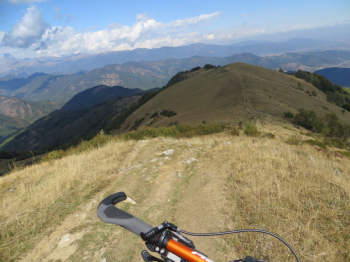
Nice ride in lower Stura Valley, with descent mostly on trails. Start with asphalt, state road 21 Colle maddalena and then provincial road 132 Valloriate hamlets, Sonvilla, Chiapue Soprana. Then leave right fork to Caricatore and continue to Colle dell'Ortiga on dirt road (little chapel in Sapè Soprano with water point). We arrive at Colle dell'Ortiga (elevation1774), in front stands the Radevil Rock. We climb to the right, eastward, to Colle Barmetta (elevation 1828), Colle Roccasson (elevation 1756) and elevation sections to l'Alpe (highest point at elevation 1798) and then on the watershed line with Val Grana we turn (orange marker) right on Rocca Stella and descend to Paraloup. Before Gorre, near Chiot Rosa spring, there is path (orange) to rocca stella-chiot rosa- le funse to the left (east), we continue straight south by gta path in the woods to borgata Bardenghi and then back to Gaiola. The ascent and descent route to Paraloup resumes the orange Tajare Park trail.
Fraternali map scale 1:25,000 Grana Valley, lower Stura di Demonte Valley.


 Italiano
 Deutsch
