Italiano
 Deutsch
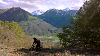
Bike Park Tajarè: giro dell'Incoronata, percorso azzurro
EXCITING ROUTE, WHICH ALLOWS YOU TO CONQUER TWO COLS, THE STUNNING CHAPEL THAT GIVES THE RING ITS NAME AND THE BIG BLUE BENCH: VIEWS OF THE STURA VALLEY ARE GUARANTEED, BUT SO IS ADRENALINE, IN THE VERY FAST RIDGE BEFORE TETTI MASUÈ, IN THE VARIANT TANA DEL DAHU AND IN THE ALWAYS TOUGH VIR DLA MADONA, NARROW SOFT-ENDURO NATURAL.
-Difficulty: easy/medium climb (MC), medium descent (MC), medium exposure (e2).
-Length: 20.4 km, elevation gain: 680 meters. Recommended period: April/November.
-Round route: Gaiola, Valloriate, Chiapue, Chapel of Sapè, Colle Valloriate, Colle del Bal, Colle dei Colli, Tetti Masuè, Chapel of the Incoronata, Moiola
-Departure and arrival: Gaiola
DESCRIPTION
From the start (Via Gugliemo Marconi) take the state road upstream (Demonte). Leaving the village, turn right uphill to Valloriate, still on asphalt. It is necessary to follow this road, ignoring all detours, to reach Serre (3.0 km) and then the main concentric of Valloriate, with the Town Hall (3.6 km). After passing a pretty little white church, you need to take the flat asphalt road to the left at the first fork. Continue always on this paved road, the climb becomes harder, you reach Chiapue (5.5 km) and then a crossroads at a small bridge (6.2 km) (always ignoring any other small road). It is necessary to keep to the left and begin a steep climb. The road continues paved but with steep inclines and an uneven surface. At km 7.4 you still keep left toward Sapè, and continue without possibility of error until the road becomes unpaved, at the Sapè Chapel. You take the hairpin bend and after a short while leave this road to turn left toward the Valloriate pass, which you reach at km 9.5. After the recommended digression to the panorama of the hill, you return to the road and face a final hard climb.
Thus begins the descent. At the second hairpin bend to the left, you take the path on the outside and shortly reach the Bal pass. Continue left on a slight descent and follow the entire Arp ridge, ignoring the small square and the signs for the Dahu Trail. At a very steep uphill trail on the left (which you ignore) you keep right; last climb then more descent on the Moiola Hills. From here you veer sharply right and after a quick descent you reach Masuè roofs. Keeping to the right you cross the houses and enter a chestnut forest. At the next forks you need to keep first right uphill and then left downhill (by a meadow). The small road becomes a path until it comes out of the woods below the chapel of the Incoronata, which is reached by pushing the bike a little on foot.
WARNING: from September 2023, just before the pushing part, a fork with double post allows you to take the left-hand Tana del Dahu variant (look for the sign from the small ravine and post a selfie) that bypasses the right-hand direction to Cappella Incoronata and Big Bench, reaching the final descent (Via dla Madona).vNormally, having reached the scenic knoll of the chapel, you descend on dirt road and at the second hairpin bend on the left take the path to reach the BIG BENCH in Moiola. Behind the bench you descend again on the small road, to be abandoned shortly after in favor of the path on the right, the Via d'la Madona, to be followed all the way and without possibility of error to the asphalt road.v Road to be followed downhill without detours to the fountain with the Washing Machine Monument (17.4 km). Turn left onto secondary asphalt road, keep to the bike path that makes the state road cross, and begin the descent to the Stiera Rafting Center. When you reach the end of the descent, after a small bridge, continue straight on the last climb back to Gaiola. At the first intersection, at the first house, turn left and take Via Piave, crossing the SS21 (19.7 km). At the Piazzetta del Pelerin turn right downhill and continue straight ahead, until the finish.