Italiano
 Deutsch
Bike Park Tajarè: anello di Paraloup, percorso giallo
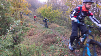
AFTER A CHALLENGING BUT STEADY CLIMB, YOU REACH PLACES THAT GUARD PARTISAN MEMORY: THE PINK CHIOT AND THE HAMLET PARALOUP, WHICH IS DEFINITELY WORTH A VISIT. AFTER A SHORT UP AND DOWN, YOU DIVE INTO ONE OF THE LONGEST (6KM) AND FLOWING SINGLETRAILS IN THE VALLEY: AN EXCITING RIDE!
-Difficulty: medium climb (MC+), medium descent (MC+), medium exposure (e2/e3)
-Length: 21.5km, Elevation gain: 750m, Recommended period: April/November.
-Round route: Gaiola- Castelletto - Rittana - Tetto sottano - Tetto Pollino - Chiot Rosa - Paraloup - Borgata Cavagna - Chiotti - Gaiola.
-Departure and arrival: Gaiola
DESCRIPTION
From the start (Via Gugliemo Marconi) take the provincial road towards Rittana. When you reach Castelletto, go left towards Rittana/Paraloup always on asphalt. After crossing Rittana, continue always on this paved road ignoring any detour until km 4.7. Here, at a left hairpin bend, you leave the road to continue on a small asphalt road that runs along a small stream. After 600 meters you make the left hairpin bend, continuing on a steeper climb. Continue on this road until the first houses, where the road bends to the right (a visit to the hamlet is recommended). Still uphill facing two more sharp bends. At the next hamlet, Mount Tajarè pops up, and you have to continue straight on asphalt ignoring every detour. You slip in between the last houses and after these you have to turn left onto a dirt track (6.8 km). You follow this dirt road through the woods ignoring every detour. In particular you need to keep left at km 7.0 and km 7.3. Pay attention at km 7.8, where you need to keep right on the uphill. After a couple of very steep hairpin bends in sequence, the small road flattens out until you reach the meadowy expanse of Chiot Rosa (8.6 km). You cross it all and take the asphalt road again on the only climb with this surface, in the direction of Paraloup. When you reach the museum hamlet, continue beyond it on a very steep path pointing toward a thicket of trees. From here with no possibility of error, between plateaus and climbs, you reach a junction, at km 11.4 (highest point of the tour).
From the right comes the connection between the orange and yellow routes. You thus continue on spectacular descent that forks after about 1 km: keep right uphill (it flattens out soon after): continue for another km still on single track , until you cross a dirt road. Turn sharply left here, downhill (ignoring shortly after a steep climb to the left) to a junction with a memorial stone (14.0 km). Take the only path to the right that runs for miles along the ridge. Ignore the trail at km 15.0 that descends to the right toward Bardenghi and the second one (15.9 km, however, barely visible). Watch out for the numerous forks at km 15.3, where you need to continue straight ahead making a short but steep climb. After a section with a few climbs, the trail turns sharply left and ends after a descent at an open space among the trees (17.1 km). In front of us an X sign indicates a private area NOT to be traveled, and indeed one easily looks for and finds one of our arrows indicating right downhill on steep little path, which continues on very fast dirt road. After a couple of repeating sharp turns (18.2 km) you leave the small road in favor of a path on the left.
You come to a new dirt road to follow to the left. After a short while you come to a small hamlet, Bricaiot. The left, level path leads to the Croce della Vaita, a very scenic point. Our itinerary involves taking the downhill path that flanks the wall. Passing between dry stone walls, the path flattens out and we leave it at the first fork to descend steeper again to the right. A couple of sharp turns and you find yourself on a convenient dirt road, to be followed to the left. Shortly back to Gaiola, you return to asphalt keeping to the left. Passing next to the church, keep left at the small traffic circle, and from here straight ahead to the finish.