Italiano
 Deutsch
Bike Park Tajarè: tour della rocca, percorso blu
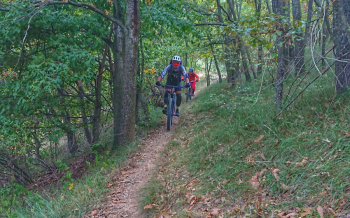
TRUE AND PURE XC IN THE EARLY PART MERGES WITH ONE OF THE MOST EXCITING FLOW SINGLETRACK ON THE BPT, THE NIGHT ROOFS/BOVO. SINCE 2023, A HARD VARIANT HAS ALSO BEEN ADDED UPHILL TO MOUNT COLLETTO, OFF-TRAIL (BUT STILL MARKED), WITH SHORT BUT INTENSE DH TRAIL TO MAKE UP THE TOUR.
-Difficulty: medium climb (MC), medium descent (MC), weak exposure (e1).
-Length: 18.1 km. Elevation gain: 650 meters. Recommended period: April/November.
-Round route: Gaiola - Castelletto di Roccasparvera - Tetti Sirol- Prà Gaudino - Tetti della notte - Roccasparvera - Piano Quinto - Stiera
DESCRIPTION
From the start (Via Guglielmo Marconi) immediately cross the state road to take the dirt road beside a private fence, Via Del Ponte Vecchio. Keeping this direction between houses, the road becomes grassy and dives downhill all the way under the Olla Bridge. After a short climb downhill again, turn right to take a cattle track in the wilderness near the river. A steep but short climb brings you back to a smoother dirt road to take a left. You go left at the next fork, come out on asphalt provincial road, turn right. Back in a grove, turn left (stake) and shortly come out on the provincial road, to be followed to the right. Continue through the hamlet Castelletto always on asphalt. After a descent, just before the little church of Madonna delle Grazie (3.7 km) turn left, steeply uphill on asphalt. After 900 meters, at the first detour, take the dirt road on the left, to be followed uphill ignoring all detours, until km 5.2, where you turn sharp right still uphill. At the first hairpin bend, you abandon this road and continue straight ahead.
Follow this small road that flattens out, climbs steeply and then dives downhill back onto asphalt (5.8 km). Left uphill, and at the first hairpin bend you return to dirt road continuing straight ahead. Now follow this small road ignoring any detours, until this time sharply to the left at some ruined houses. Here you take the path on the right that crosses with several false plains large chestnut woods. As soon as the path begins to descend a little steeper, between dry stone walls, you abandon it at the first bend to the left, veering steeply but briefly uphill to the right. From here a beautiful path takes you downhill, with no possibility of error, passing the abandoned hamlet of Tetti Bovo. The path returns to a dirt road, to be followed to the end, always downhill, ignoring all other detours.
You reach Roccasparvera on asphalt, a few meters on the provincial road, then immediately left downhill. You go alongside the cemetery and arrive in the village. Still straight ahead until you reach a small votive pillar, where you turn sharply left, still going downhill, until you cross a new paved road (11.1 km). This is to be followed to the right, cross the dam bridge and at the votive pillar turn right again. Straight ahead to the steep climb that leads back to the side of the state road (12.4 km). Cross it in the direction of the houses and immediately turn right, then straight ahead until you come back near the state road, where you continue on this paved bike path to the left on a slight uphill slope. Reaching a road sign near a thicket of trees (13.6 km) take the path to the right downhill. Coming out of the woods you stay on the central path, after 100 meters you cruva sharply to the left and at the bottom of the descent you continue on a short climb. After a short while you plunge downhill into the river gorges, cross a small bridge and continue to the Stiera rafting center. Back on the asphalt, turn right on the last climb back to Gaiola. At the first intersection, at the first house, turn left and take Via Piave, crossing the SS21 (38.8 km). At the Piazzetta del Pelerin turn right downhill and continue straight ahead, until the finish.