Italiano
 Deutsch
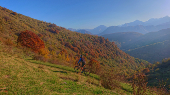
Bike Park Tajarè: pendici del Tajaré, percorso verde
AFTER A LONG AND CHALLENGING CLIMB WE REACH THE SLOPES OF TAJARÈ MOUNTAIN, OUR SYMBOL. PEDALING ALONG THE SLOPES ON A BEAUTIFUL XC SINGLETRACK GIVES EMOTIONS AND BREATHTAKING VIEWS. FINAL ON FAST DIRT TRACKS THAT PASS THROUGH BEAUTIFUL HAMLETS AND CHESTNUT FORESTS.
-Difficulty: easy/medium climb (MC), medium descent (MC), medium exposure (e2)-.
-Length: 22 km, elevation gain: 770 meters. Recommended period: April/November.
-Round route: Gaiola - Valloriate - Chiapue - Caricatore - Malga della Presa - Chiotti - Cappella e Castagno secolare dla Moutta - Cappella San Bernardo - Braida - Gaiola
-Departure and arrival: Gaiola
DESCRIPTION
From the start (Via Gugliemo Marconi) take the state road upstream (Demonte). Leaving the village, turn right uphill to Valloriate, still on asphalt. It is necessary to follow this road, ignoring all detours, to reach Serre (3.0 km) and then the main concentric of Valloriate, with the Town Hall (3.6 km). After passing a pretty little white church, you need to take the flat asphalt road to the left at the first fork. Continue always on this paved road, the climb becomes harder, you reach Chiapue (5.5 km) and then at a crossroads at a small bridge (6.2 km) you keep to the right (always ignoring any other small road). From here cross the stream over the small bridge and continue on this road again, ignoring any small roads or paths that branch off from it. You pass several hamlets and at km 8.4 the road becomes unpaved.
It crosses the stream again and on the right orographic slope, the road immediately climbs with steep gradients and a difficult surface. It soon flattens out and returns again to the opposite side, exposed to the sun. After 3 hairpin bends, when you reach the fourth you ignore the path entering the valley and continue on this dirt road. Without any possibility of error, through the green meadows of Mount Tajarè, you reach Gias della Presa, a magnificent mid-mountain pasture (11.4 km). The trail continues at the same altitude on a path in a continuous up and down, until it becomes a grassy lane. After a short while you abandon it in favor of a path to the left (14.0 km) that leads upstream to the hamlet of Chiotti.
You have reached the trivium at which theParaloup Ring also arrives. From here you go right on a dirt road: you need to slow down in view of the first houses of the Chiotti hamlet and take the path that descends between the houses on the left, near a wash-house fountain: you follow a fairly steep path (with short technical steps) that dips and shortly reaches the lower part of the hamlet (abandoned) and, with a final steep traverse, comes out near the chapel of Sant'Anna della Moutta. You take a left and shortly reach the Monumental Chestnut Tree; continue straight on a dirt road. At km 17.3 you return to asphalt, to be taken to the left for a last short climb. You reach the 18th-century chapel of San Bernardo, behind which you take a dirt road downhill. Ignoring the two small roads that branch off to the right (18.2 km and 19.1 km), the road becomes paved and continues downhill. After a few bends in the village of Braida, it is necessary to turn left onto a flat dirt road with a very good surface (20.6 km). Shortly back to Gaiola, return to asphalt keeping to the left. Passing by the church, at the small traffic circle keep left, and from here always straight until the finish.
WARNING. In the summer season there may be shepherds and animals at the end of the climb, at the Malga della Presa: it is recommended to slow down; maximum respect for those working! Go through any gates and/or ropes taking care to close them again and maintain altitude to continue.