Italiano
 Deutsch
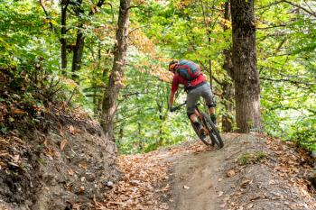
Bike Park Tajarè: Yeti Trail, il Sentiero di Aldo

DEDICATED TO BIKER ALDO, BPT'S FIRST ENDURO TRAIL DOESN'T LEAVE A MOMENT TO BREATHE BETWEEN BANKED PARTS, CHANGES OF SLOPE, PASSAGES BETWEEN TREES AND ROOTS, DROPS ALL AVOIDABLE. GRAND FINALE ON TOBOGA NATURAL: THE ADRENALINE WILL BE FLOWING!
-Length: 1.5km
-Difference: 210m (-)
-Recommended period: April-November in the absence of snow CLOSED FROM OCTOBER TO MID NOVEMBER FOR CASTAGNE COLLECTION.
-Descent Enduro, medium difficulty.
-Departure: on orange trail, at locality Pertus del Colletto: trail entrance from wooden sign hanging with chain.
-Finish: at Cà Pra dei Cotti and Tetti Balotte localities.
-ACCESSES, in descending order:
- pedal the orange Track Ortiga&Alpe route: Yeti is located about 2/3 of the loop OR
- pedal on the yellow Ring of Paraloup trail to the Chiot Rosa picnic area, from here take the orange trail, uphill OR
- pedal on the yellow Ring of Paraloup route, take the detour to the right on asphalt uphill, signposted Chesta-Bergia-Scanavasse: once at the latter, take the orange route downhill.
- SHORT RING from Rittana: at the end of the village, take a right on asphalt on Via Monte Grappa uphill to Borgata Tetto Rimet (keep right) and engage the downhill orange route.
DESCRIPTION
The first trail for the exclusive use of bikers, signed by trailbuilder Matteo Tesio and the BPT crew. The trail, created thanks to donations in memory of Aldo, a lover of our trails, starts from the Pertus del Colletto along the orange Track Ortiga and Alpe trail. It starts immediately with a couple of backing turns that make the adrenaline spurt high! It continues on a super flow surface in the wild forest with straight and leaning turns. It then continues on a super natural ridge among birch trees and then again down into a fir forest that tastes very much like a Canadian forest, with fast turns and scattered roots, all very natural flow. It closes in a natural toboggan, salvaged from an old military mule track, leading toward the finish. Challenging trail but rideable by all mountain bikers as the gradient is never excessive and the jumps not mandatory. 1.5 km of pure fun!
RECOMMENDATIONS
-Medium difficulty ENDURO trail, NOT suitable for beginners.
-Recommended protections.
-Descend at a speed and spacing appropriate to your ability.
-At the two intersections on dirt road, be careful and decrease speed.
-At the end of the trail, follow the signs STARTING POINT Gaiola: in summer exit to the right (respect for closing in the farmyard at the end of the trail), in other seasons exit to the left
IT IS RECOMMENDED TO SLOW DOWN AFTER FINISHING YETI: RESPECT AND OBSERVATION OF TRAFFIC LAWS ARE THE BASIS FOR SURVIVAL OF THE BPT.