Italiano
 Deutsch
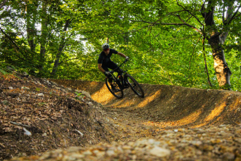
Bike Park Tajarè: Dahu Trail

UNIQUE TRAIL IN PIEDMONT IN A FREE BIKE AREA, IT ALTERNATES DOZENS OF BANKS ALL TO RIDE: SKILL IN HARNESSING GRAVITY WILL EXPONENTIALLY INCREASE THE FUN! MUMPS, RELAUNCHES, TWO COBBLESTONES AND A PANCAKE-RAMP LAUNCH ARE THE OUTLINE OF THIS EXCITING RIDE THAT LEAVES AND RESUMES THE BLUE TRAIL.
-Length: 2.5km
-Difference in elevation: 230m (-)
-Recommended period: April-November in the absence of snow. GIVEN ITS EXPOSURE, NOT RECOMMENDED IMMEDIATELY AFTER HEAVY RAINS.
-Descent Enduro, medium difficulty.
-Departure: on the blue route Giro dell'Incoronata, after Colle del Bal: trail entrance from the small square with bench and directions.
-Return: bypassing part of the above trail and the hamlet Tetti Masuè, return always on the blue trail, just before the single-track that precedes the Chapel of the Incoronata
-ACCESSES, in descending order:
1) ride on the blue route Tour of the Kornati, DAHU is located about halfway OR
2) SHORT RING REPEATABLE: drive up on asphalt from Moiola to Borgata Tetti Masuè (signs Asineria dei Colli), park in the large widening-parking lot on the right just before the hamlet, follow the blue route in reverse and after a few meters follow the D's to the access. WARNING: very steep 1 km climb on bumpy and very grassy dirt road in warm weather. It does not present difficulties in E-bike, OC for those pedaling in muscular. When you reach the end of DAHU, follow the Tetti Masuè arrow to return to the starting point.
DESCRIPTION
Second trail for bikers only use, signed trailbuilder Matteo Tesio & BPT crew. The trail was created thanks to the fundamental economic contribution in primis of the Municipality of Moiola, the Social Cooperative Proposta80 and, last but not least, of your micro-donations for the last crowdfunding! It is located just after the Colle del Bal, halfway along the blue route (Giro dell'Incoronata). Consisting of as many as 24 hairpins, it starts immediately with several banked curves with minimal gradient. The mega Sepang banked turn precedes the ?Jump into the green, a completely dirt hump that can be copied safely. This is followed by a change of gradient (warning sign) with three gradually steeper banked curves: the most technical part of the trail. A stony traverse precedes the shadiest part of the trail (beech forest), until you reach an avoidable super-peak that can always be copied according to your skills. A slightly steeper part precedes the rock garden and the final curves, before arriving in the widening directly on the blue trail (arrows, continue right) .Challenging trail but rideable by all mountain bikers as the gradient is almost never excessive and the hump jumps copyable or avoidable. Over 2km not to be taken lightly!
RECOMMENDATIONS
-Medium difficulty ENDURO trail, NOT suitable for beginners.
-Recommended protections.
-Descend at a speed and spacing appropriate to your ability.
IT IS RECOMMENDED TO SLOW DOWN AFTER FINISHING DAHU, AS YOU WILL BE BACK ON THE BLUE ROUTE (XC/ALL MOUNTAIN) WHICH IS SHARED AND AT THE END OF THE RIDE INCLUDES A PART ON ASPHALT. RESPECT AND OBSERVATION OF TRAFFIC LAWS ARE THE BASIS FOR BPT SURVIVAL.