Italiano
 Deutsch
Bike Park Tajarè: track Ortiga & Alpe, percorso arancione
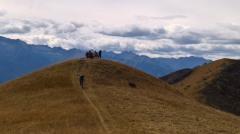
THE LONGEST AND TOUGHEST LOOP, BUT WITH FANTASTIC 360° SUMMIT VIEWS OF THE COZIE AND MARITIME ALPS AND TWO MILE-LONG SINGLETRACKS (CROSS ROCCA STELLA-CHIOT ROSA + DH FUNSE) THAT WILL MAKE YOU SCREAM WITH PLEASURE! FINAL ON QUIET DIRT TRACKS IN SPECTACULAR RIVER ENVIRONMENT.
-Difficulty: medium+ ascent (BC), BC+ descent, strong exposure (e3).
-Length: 38.3 km, Elevation gain: 1450m. Recommended period: May/November.
-Round route: Gaiola - Valloriate - Chiapue - Chapel of the Sape - Colle Ortiga - Alpe di Rittana - Gias dell'Alpe - Paraloup - Chiot Rosa - Le Funze - Pertus del Colletto - Roccasparvera - Piano Quinto - Stiera - Gaiola
-Departure and arrival: Gaiola
DESCRIPTION
From the start (Via Gugliemo Marconi) take the state road upstream (Demonte). Leaving the village, turn right uphill to Valloriate, still on asphalt. It is necessary to follow this road, ignoring all detours, to reach Serre (3.0 km) and then the main concentric of Valloriate, with the Town Hall (3.6 km). After passing a pretty little white church, you need to take the flat asphalt road to the left at the first fork. Continue always on this paved road, the climb becomes harder, you reach Chiapue (5.5 km) and then a crossroads at a small bridge (6.2 km) (always ignoring any other small road). It is necessary to keep to the left and begin a steep climb. The road continues paved but with steep inclines and an uneven surface. At km 7.4 keep left again towards Sapè, and continue without any possibility of error until the road becomes unpaved, at the Sapè Chapel. You ride the hairpin bend and after a while ignore the two detours (first to the right and then to the left) continuing straight uphill. You continue uphill on this route all the time, ignoring all other detours. You pass through grassy and wooded areas until you reach a semi-flat section at the entrance to the fairy forest (12.1 km). From here you soon reach the dirt road that climbs from Demonte (12.8 km) to be followed uphill to the right. The climb continues with steep inclines until reaching the Ortiga Pass at km 14.6. The exertions are not over because it is necessary to climb again to the right, taking the only path that after a very steep climb descends to a col and enters the woods. The path, continuously up and down and with no further detours, allows you to get to overlook Mount Tajarè and the Alpe di Rittana, before plunging steeply downhill to the Rochasson pass (17.4 km).
The next 4.5 km are all downhill and on spectacular trail. You descend continuing the ridge, pass the Arpiola cross and come to a sharp bend. You pass a thicket of trees and continue across the large grasslands to a plateau, by some watering troughs for the cow herds. From here a spectacular trail starts to the right, allowing you to change route and walk the entire descent of the Paraloup Ring (VARIANT on yellow route). To continue on the orange, go straight for a short distance and at km 19.8 veer sharply to the left. Continue again on the flat and then downhill again. At the next two detours you must always keep left. You thus arrive alongside the asphalt road, staying to the left to ride the last stretch of trail again, until you reach Chiot Rosa (22.4 km). We resume pedaling uphill, taking the dirt road that departs in front of us, to the left of the wooden building. Ignoring any detours, after a hard climb you descend to Le Funse (24.5 km). From here we continue straight ahead slightly uphill, keeping on the narrow path, until we take a detour to the right (signposted Bagot): the beautiful DH FUNSE singletrack, initially technical and with avoidable drops, then continues smoother and faster until we reach the dirt road above the hamlet of Scanavasse (26.6 km).
Reaching the asphalt in front of us, it is necessary to leave it immediately, turning sharply left onto a new dirt road, also to be followed ignoring any other detour. After a short stretch of easy ascent we arrive at Pertus del Colletto, a crossroads of paths and small roads (29.3 km). Ignore the signs for the Yeti trail. Our trail is the one that continues ahead of us, on the right, level. Soon it becomes a small dirt road downhill. After a sharp bend and a small house (29.9 km) we continue straight uphill, then downhill again ignoring any detours and returning to a paved road (31.6 km). Continue downhill to the provincial road, to be crossed in the direction of the small church, then descend alongside it toward Roccasparvera. Past the Bolleris gate, keep to the right downhill until you cross a new paved road. This is to be followed to the right, cross the dam bridge and at the votive pillar turn right again. Straight ahead until the steep climb that brings you back to the side of the state road (34.4 km).
You cross it in the direction of the houses and immediately turn right, then straight ahead until you come back near the state road, where you continue on this paved bike path to the left on a slight uphill slope. Reaching a road sign near a thicket of trees (35.6 km) take the path to the right downhill. Coming out of the woods you stay on the central path, after 100 meters you cruva sharply to the left and at the bottom of the descent you continue on a short climb. After a short while you plunge downhill into the river gorges, cross a small bridge and continue to the Stiera rafting center. Back on the asphalt, turn right on the last climb back to Gaiola. At the first intersection, at the first house, turn left and take Via Piave, crossing the SS21 (38.8 km). At the Piazzetta del Pelerin turn right downhill and continue straight ahead, until the finish.
-Ignore the RAMP MTB signs that are part of another and different route.
-To make the VARIANT with entry on the yellow route, it is necessary, having arrived downhill at the Malga dell'Alpe near the watering troughs, to follow the signs to the right: a short climb first and then a fast singletrack will make you enter the yellow route downhill to Gaiola.