HOME RANKINGS CHALLENGES ROUTES NEAR ME PLANNING SEARCH LOGIN
Italy - Lombardia, BS
2024/06/26 08:43:00

I sentieri dell'aquila: Val Canè, Bocchetta di Val Massa, S.Apollonia
24 Downloads
2
 
Share

Key Takeaways / Scheda Tecnica

Disciplina:
Mountain Bike (MTB)
Percorso:
I sentieri dell'aquila: Val Canè, Bocchetta di Val Massa, S.Apollonia
Località:
Italy - Lombardia, BS
Distanza:
31,48 km
Dislivello Positivo:
+1 800 mt (Quota Min: 1107m - Max: 2620m)
Difficoltà Tecnica:
4/5
Valutazione Panorami:
5/5
Formato Traccia:
GPX Download disponibile
Author
giannig
(36)
Place
Italy - Lombardia, BS
Km
31,48 km
Elapsed time
08:00:22
Vertical meters
+1 800 mt (1107 - 2620)
Route difficulty
Landscapes
Last update
2024/06/27 11:35:52
Comments
2
Description

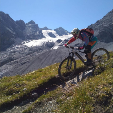
Mountain biking inside a fairy tale, from the magic of Val Canè, to the high altitude military posts of Bocchetta di Val Massa, passing by the Coleazzo, Prisgai and Somalbosco huts to the bottom of Val delle Messi. Really nice tour with great views of the peaks of the Adamello Presanella Group.

Foto itinerario MTB I sentieri dell'aquila: Val Canè, Bocchetta di Val Massa, S.Apollonia - Italy - Lombardia, BS

Start in Temù, pedalable climb to Cortebona in Val Canè, then along the beautiful trail 155 inside a perfect larch forest. Pushing but not heavy at all, here and there a few short pedaled sections, passing by malga Coleazzo, bewitched by the amazing view.

Foto itinerario MTB I sentieri dell'aquila: Val Canè, Bocchetta di Val Massa, S.Apollonia - Italy - Lombardia, BS

Foto itinerario MTB I sentieri dell'aquila: Val Canè, Bocchetta di Val Massa, S.Apollonia - Italy - Lombardia, BS

Foto itinerario MTB I sentieri dell'aquila: Val Canè, Bocchetta di Val Massa, S.Apollonia - Italy - Lombardia, BS

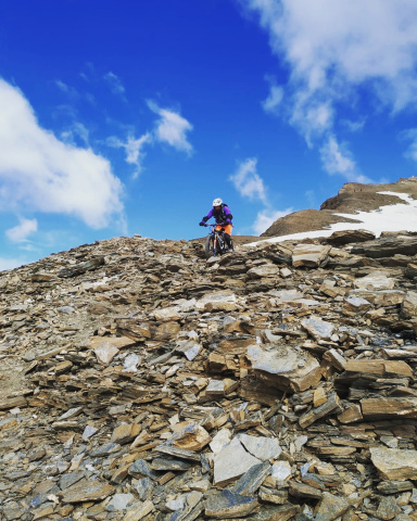
Reaching Bocchetta di Val Massa, 2499 meters, you admire the military fortifications of the Great War, climbing with the bike on your back for a hundred meters to an altitude of 2610.

Foto itinerario MTB I sentieri dell'aquila: Val Canè, Bocchetta di Val Massa, S.Apollonia - Italy - Lombardia, BS

Foto itinerario MTB I sentieri dell'aquila: Val Canè, Bocchetta di Val Massa, S.Apollonia - Italy - Lombardia, BS

Descent a bit hard and exposed in the first hundred meters, beautiful and intriguing, then easier, rocky at the beginning, mixed pine needles, fixed rock, passing by the Prisigai and Finalbosco huts, to Sant'Appollonia, at the bottom of the Val delle Messi, down trail 154.

Download our free mobile app to send this route to your Garmin device or to navigate it on OSM maps. Android - iOS
Local weather
Tue 00:00
8 °C
Tue 12:00
11 °C
Wed 00:00
9 °C
Wed 12:00
11 °C
Thu 00:00
9 °C
Thu 12:00
11 °C
Fri 00:00
5 °C
Fri 12:00
8 °C
Sat 00:00
4 °C
Sat 12:00
9 °C

Graph

Nearest Routes

2024/06/25
- Italy - Lombardia, BS
giannig
(36)
31,58 km
Km
+1 800 mt
Vertical meters
Route difficulty
Landscapes
34,63 km
Km
+2 065 mt
Vertical meters
Route difficulty
Landscapes
2023/08/27
- Italy - Lombardia, BS
giannig
(36)
28,02 km
Km
+1 700 mt
Vertical meters
Route difficulty
Landscapes
2023/02/05
- Italy - Lombardia, BS
ValeBG
(181)
35,06 km
Km
+1 400 mt
Vertical meters
Route difficulty
Landscapes
2022/11/12
- Italy - Lombardia, BS
29,54 km
Km
+1 485 mt
Vertical meters
Route difficulty
Landscapes
2023/09/30
- Italy - Lombardia, BS
makihl
(3)
41,28 km
Km
+1 800 mt
Vertical meters
Route difficulty
Landscapes
2026/07/29
- Italy - Lombardia, SO
yura
(15)
76,69 km
Km
+4 649 mt
Vertical meters
Route difficulty
Landscapes
2022/08/16
- Italy - Lombardia, BS
giannig
(36)
26,38 km
Km
+1 800 mt
Vertical meters
Route difficulty
Landscapes
2023/09/01
- Italy - Lombardia, BS
Giulien
(110)
47,19 km
Km
+2 587 mt
Vertical meters
Route difficulty
Landscapes
2023/09/14
- Italy - Trentino-Alto Adige/Südtirol, TN
giannig
(36)
17,55 km
Km
+1 200 mt
Vertical meters
Route difficulty
Landscapes

2 Comments