HOME RANKINGS CHALLENGES ROUTES POI PLANNING SEARCH LOGIN
Italy - Lombardia, BS
2023/09/30 19:25:13

Dosso Bolon + Gallo Trail

3 Downloads
0
 
Author
makihl
(3)
Place
Italy - Lombardia, BS
Km
41,28 km
Elapsed time
07:15:29
Vertical meters
+1 800 mt (1517 - 2622)
Route difficulty
Landscapes
Last update
2023/09/30 22:46:21
Comments
0
Description

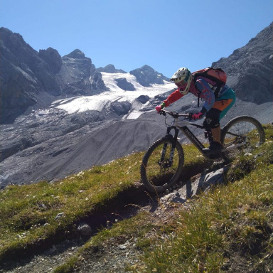
Wonderful route that runs along both sides of Gavia, suitable for those who like technical descents.

Departure from Sant'Apollonia and ascent on asphalt to the Gavia Pass. From Lago Bianco begins a beautiful trail that descends to Valfurva. Initially it is easy and fast, with a few firm climbs, but as it gradually becomes more challenging (but never overdo it) and the exposure increases, so ride with some caution. In the last section there are a few hairpin bends and some interesting little rock passages that make this trail a real spectacle! Back on the asphalt just above Santa Caterina you return to the pass and descend to Black Lake where the Gallo Trail begins. This is definitely more challenging and very physical, it doesn't let up for a moment! Rocky bottom with some sections a bit bumpy, steps, switchbacks and inclines are not lacking--a spectacle!


Download our free mobile app to send this route to your Garmin device or to navigate it on OSM maps. Android - iOS

Graph

Nearest Routes

2022/08/16
- Italy - Lombardia, BS
giannig
(17)
26,38 km
Km
+1 800 mt
Vertical meters
Route difficulty
Landscapes
2023/09/01
- Italy - Lombardia, BS
Giulien
(110)
47,19 km
Km
+2 587 mt
Vertical meters
Route difficulty
Landscapes
2022/11/12
- Italy - Lombardia, BS
29,54 km
Km
+1 485 mt
Vertical meters
Route difficulty
Landscapes
2022/09/21
- Italy - Lombardia, BS
61,28 km
Km
+2 339 mt
Vertical meters
Route difficulty
Landscapes
2023/02/05
- Italy - Lombardia, BS
ValeBG
(131)
35,06 km
Km
+1 400 mt
Vertical meters
Route difficulty
Landscapes
2023/08/27
- Italy - Lombardia, BS
giannig
(17)
28,02 km
Km
+1 700 mt
Vertical meters
Route difficulty
Landscapes
2023/09/14
- Italy - Trentino-Alto Adige/Südtirol, TN
giannig
(17)
17,55 km
Km
+1 200 mt
Vertical meters
Route difficulty
Landscapes
2022/11/07
- Italy - Lombardia, SO
21,01 km
Km
+730 mt
Vertical meters
Route difficulty
Landscapes
2022/11/06
- Italy - Lombardia, SO
36,20 km
Km
+1 141 mt
Vertical meters
Route difficulty
Landscapes
2023/09/14
- Italy - Lombardia, SO
38,71 km
Km
+2 134 mt
Vertical meters
Route difficulty
Landscapes

0 Comments