HOME RANKINGS CHALLENGES ROUTES NEAR ME PLANNING SEARCH LOGIN
Italy - Trentino-Alto Adige/Südtirol, BZ
2023/03/06 21:10:17

Valle di Avigna

21 Downloads
2
 
Share

Key Takeaways / Scheda Tecnica

Disciplina:
Mountain Bike (MTB)
Percorso:
Valle di Avigna
Località:
Italy - Trentino-Alto Adige/Südtirol, BZ
Distanza:
47,44 km
Dislivello Positivo:
+1 800 mt (Quota Min: 958m - Max: 2307m)
Difficoltà Tecnica:
4/5
Valutazione Panorami:
4/5
Formato Traccia:
GPX Download disponibile
Author
nonnocarb
(324)
Place
Italy - Trentino-Alto Adige/Südtirol, BZ
Km
47,44 km
Elapsed time
06:35:51
Vertical meters
+1 800 mt (958 - 2307)
Route difficulty
Landscapes
Last update
2023/03/07 14:23:23
Comments
0
Description

Very scenic but also very hard route, especially the challenging climb along the Avigna valley.
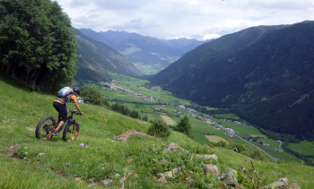
Foto itinerario MTB Valle di Avigna - Italy - Trentino-Alto Adige/Südtirol, BZ

From the soccer field in Calva you go up along the bicycle path to Tubre. From here you take to the Avigna valley on a very steep road, then on a forest road. The valley is very beautiful and almost completely rideable to the top, minus the last 20 minutes to push up to the Crocetta pass.
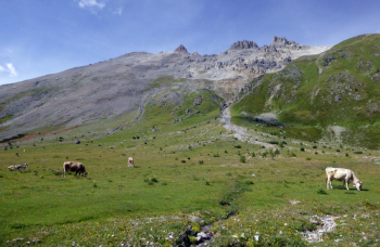
Foto itinerario MTB Valle di Avigna - Italy - Trentino-Alto Adige/Südtirol, BZ

From here an initially challenging trail leads into Switzerland. At the fork go up on forestry to the Costainas pass with nice views, then quick descent to the village of Lü. Here watch out for the fork and climb up on the left to avoid the valley floor asphalt and go for the nice finle path down to Müstair, with the beautiful monastery. Cross the border on the bike path and return to the start, not without taking one last nice trail through the forest.
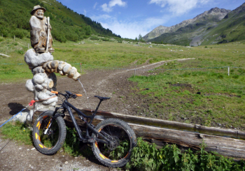
Foto itinerario MTB Valle di Avigna - Italy - Trentino-Alto Adige/Südtirol, BZ

Download our free mobile app to send this route to your Garmin device or to navigate it on OSM maps. Android - iOS
Local weather
Tue 00:00
9 °C
Tue 12:00
11 °C
Wed 00:00
10 °C
Wed 12:00
13 °C
Thu 00:00
8 °C
Thu 12:00
9 °C
Fri 00:00
7 °C
Fri 12:00
9 °C
Sat 00:00
5 °C
Sat 12:00
8 °C

Graph

Nearest Routes

2023/09/27
- Italy - Trentino-Alto Adige/Südtirol, BZ
77,02 km
Km
+3 100 mt
Vertical meters
Route difficulty
Landscapes
2026/08/20
- Italy - Trentino-Alto Adige/Südtirol, BZ
nonnocarb
(324)
102,72 km
Km
+2 400 mt
Vertical meters
Route difficulty
Landscapes
2026/08/28
- Italy - Trentino-Alto Adige/Südtirol, BZ
20,14 km
Km
+1 072 mt
Vertical meters
Route difficulty
Landscapes
2026/08/27
- Italy - Trentino-Alto Adige/Südtirol, BZ
37,10 km
Km
+1 550 mt
Vertical meters
Route difficulty
Landscapes
2023/02/26
- Italy - Trentino-Alto Adige/Südtirol, BZ
nonnocarb
(324)
12,46 km
Km
+900 mt
Vertical meters
Route difficulty
Landscapes
2023/03/04
- Italy - Trentino-Alto Adige/Südtirol, BZ
nonnocarb
(324)
85,06 km
Km
+2 720 mt
Vertical meters
Route difficulty
Landscapes
2025/11/10
- Italy - Trentino-Alto Adige/Südtirol, BZ
nonnocarb
(324)
85,80 km
Km
+2 800 mt
Vertical meters
Route difficulty
Landscapes
2023/07/18
- Italy - Trentino-Alto Adige/Südtirol, BZ
kcolrah
(5)
48,77 km
Km
+1 461 mt
Vertical meters
Route difficulty
Landscapes
2024/02/02
- Italy - Trentino-Alto Adige/Südtirol, BZ
nonnocarb
(324)
16,43 km
Km
+1 000 mt
Vertical meters
Route difficulty
Landscapes
2023/02/26
- Italy - Trentino-Alto Adige/Südtirol, BZ
nonnocarb
(324)
36,98 km
Km
+800 mt
Vertical meters
Route difficulty
Landscapes

0 Comments