Italiano
 Deutsch
Val d'Uina e forcella Sassalba
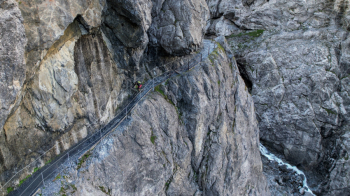
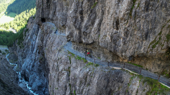
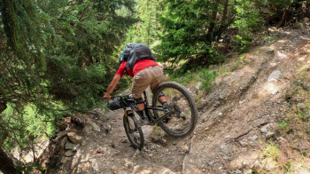
Great tour that crosses two valleys of rare beauty I decided to divide it in two days sleeping in tents to fully enjoy the emotions that can give these places. We start from the Monastero valley and climb to the Sesvenna refuge, the climb is entirely cyclable up to the pass except for 2 deadly ramps before the refuge doable in the saddle only for the most trained. You continue downhill initially on a nice flow trail and then thread your way into the famous Val d'Uina, one of those places you have to go to at least once in your life. The trail is never overly technical but very exposed, you have to be extremely careful and in case continue on foot. The last part of the descent will unfortunately be on forestry always in a resounding environment
Arrived at the small village of Scuol you start climbing again through the S-Charl valley, very long, eternal but so beautiful that it will make you feel less fatigue. When you reach the pass you can continue straight ahead but descending on forestry or follow my detour to the left continuing pushing the bike uphill to the Sassalba pass. From here starts a beautiful descent that will take you entirely on trail to the village of Mustair. Return to the starting point on bike path.
- Both descents can be categorized as S2 with some passages in S3 to be done in nosepress.
- The section carved into the rock is extremely exposed, if you suffer this condition avoid this ride.
- It can be done without a tent sleeping either at the Sesvenna hut or in Scuol and or in the little village of S-Charl (depends on where you want to start the tour).
- It can also be done in one day by getting help from the bus from Scuol up to the village of S-Charl with Bike transport service, it will save you about 700 meters in elevation gain.