
 Italiano
 Deutsch
2025/11/10 18:33:25
Alta Via della val Venosta
Author

Place
Italy - Trentino-Alto Adige/Südtirol, BZ
Km
85,80 km
Elapsed time
06:53:43
Vertical meters
+2 800 mt (730 - 1750)
Route difficulty
Landscapes
Last update
2025/11/10 21:59:26
Comments
Hotels
Description
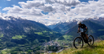
Beautiful route along the Venosta Valley High Route, a fully marked trail in the forests of the Montesole of the Upper Venosta Valley.
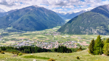
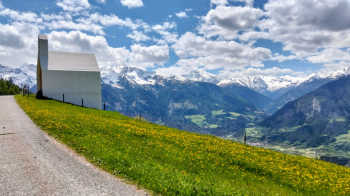
Quite challenging because of the considerable total elevation gain and numerous ups and downs with fairly steep climbs and some small sections to be done on foot, but with splendid views of the Ortler and Stelvio glaciers.
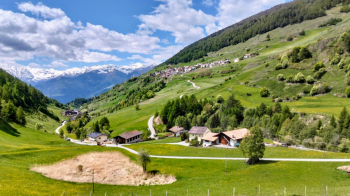
The lower part is all on the bike path from Silandro to San Valentino alla Muta and you can start from any of the villages along the bike path.
The upper part, on the other hand, is very long, having to pass along all the side valleys and with many climbs and descents, but almost all on forest roads or non-technical trails.
Ideal to do by ebike.
Local weather
Thu 00:00

15 °C
Thu 12:00

25 °C
Fri 00:00
18 °C
Fri 12:00

23 °C
Sat 00:00

18 °C
Sat 12:00
24 °C
Graph
Nearest Routes
2023/07/18
- Italy - Trentino-Alto Adige/Südtirol, BZ 48,77 km
Km
+1 461 mt
Vertical meters
Route difficulty
Landscapes
2023/03/04
- Italy - Trentino-Alto Adige/Südtirol, BZ 85,06 km
Km
+2 720 mt
Vertical meters
Route difficulty
Landscapes
77,02 km
Km
+3 100 mt
Vertical meters
Route difficulty
Landscapes
47,44 km
Km
+1 800 mt
Vertical meters
Route difficulty
Landscapes
12,46 km
Km
+900 mt
Vertical meters
Route difficulty
Landscapes
31,43 km
Km
+1 420 mt
Vertical meters
Route difficulty
Landscapes
2023/02/26
- Italy - Trentino-Alto Adige/Südtirol, BZ 36,98 km
Km
+800 mt
Vertical meters
Route difficulty
Landscapes
32,12 km
Km
+876 mt
Vertical meters
Route difficulty
Landscapes
2023/07/03
- Italy - Trentino-Alto Adige/Südtirol, BZ 62,82 km
Km
+2 000 mt
Vertical meters
Route difficulty
Landscapes
2023/03/02
- Italy - Trentino-Alto Adige/Südtirol, BZ 40,98 km
Km
+1 980 mt
Vertical meters
Route difficulty
Landscapes