HOME RANKINGS CHALLENGES ROUTES POI PLANNING SEARCH LOGIN
Italy - Trentino-Alto Adige/Südtirol, BZ
2023/07/18 19:08:13

I briganti di Mazia (da Malles, Val Venosta)

5 Downloads
1
 
Author
kcolrah
(3)
Place
Italy - Trentino-Alto Adige/Südtirol, BZ
Km
48,77 km
Elapsed time
06:52:15
Vertical meters
+1 461 mt (839 - 1682)
Route difficulty
Landscapes
Last update
2023/07/18 22:44:10
Comments
0
Description

Itinerary starting and ending in Malles, Vinschgau (1000 meters above sea level). This is a technically simple tour, almost all on paved forest or secondary roads, with only a couple of points where you should be careful if you are not particularly prepared, but both times it is only a few dozen meters. It is entirely signposted (photo 1); water can be found at several drinking fountains up to Mazia, then you have to turn to the farms along the way or drink from the streams.

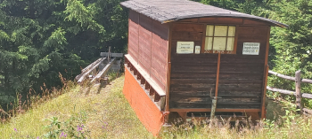
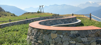
You start in Malles uphill, leaving the village the road becomes unpaved; after the first 7 km you are at Mallettes (photos 2 and 3) at about 1580 meters. At the beginning of the descent there is a viewpoint with a large swing overlooking the valley and a winding structure on which the various peaks in view are marked with their respective heights. From here you remain at altitude for much of the route with variations of a few hundred meters (maximum gradient of 14 percent on a paved section of about 600 meters after the Mallettes). From Mazia you climb on a paved road to Glies di fuori (San Sebastiano chapel at about 1700 msl), the least exciting part of the tour also because it is entirely under the sun. Then you resume a forest road with a few more ups and downs in the forest.

At about 31.5 km from the start you definitely start descending again, first on forestry and then on asphalt to Sluderno (860 msl) from where you return to Malles following the Vinschgau cycle path.

Photo 1: signs on the route

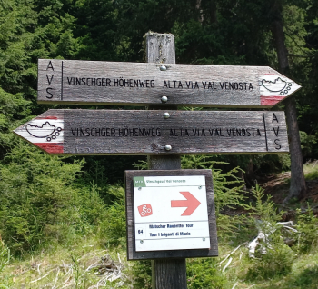
Photo 2: the Mallettes

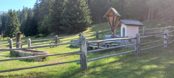
Photo 3: vantage point over the Venosta Valley

Bee condos (if you find a couple of them along the route and pass by them, if you are allergic pay attention (however they quietly ignored me):

Download our free mobile app to send this route to your Garmin device or to navigate it on OSM maps. Android - iOS

Graph

Nearest Routes

2023/03/04
- Italy - Trentino-Alto Adige/Südtirol, BZ
nonnocarb
(266)
85,06 km
Km
+2 720 mt
Vertical meters
Route difficulty
Landscapes
2023/09/27
- Italy - Trentino-Alto Adige/Südtirol, BZ
77,02 km
Km
+3 100 mt
Vertical meters
Route difficulty
Landscapes
2023/03/06
- Italy - Trentino-Alto Adige/Südtirol, BZ
nonnocarb
(266)
47,44 km
Km
+1 800 mt
Vertical meters
Route difficulty
Landscapes
2023/02/26
- Italy - Trentino-Alto Adige/Südtirol, BZ
nonnocarb
(266)
12,46 km
Km
+900 mt
Vertical meters
Route difficulty
Landscapes
2023/03/06
- Italy - Trentino-Alto Adige/Südtirol, BZ
nonnocarb
(266)
31,43 km
Km
+1 420 mt
Vertical meters
Route difficulty
Landscapes
2023/02/26
- Italy - Trentino-Alto Adige/Südtirol, BZ
nonnocarb
(266)
36,98 km
Km
+800 mt
Vertical meters
Route difficulty
Landscapes
2023/02/26
- Italy - Trentino-Alto Adige/Südtirol, BZ
nonnocarb
(266)
32,12 km
Km
+876 mt
Vertical meters
Route difficulty
Landscapes
2023/03/02
- Italy - Trentino-Alto Adige/Südtirol, BZ
nonnocarb
(266)
40,98 km
Km
+1 980 mt
Vertical meters
Route difficulty
Landscapes
2023/07/03
- Italy - Trentino-Alto Adige/Südtirol, BZ
@ff.mtb
(9)
62,82 km
Km
+2 000 mt
Vertical meters
Route difficulty
Landscapes
2023/03/04
- Italy - Trentino-Alto Adige/Südtirol, BZ
nonnocarb
(266)
84,83 km
Km
+2 050 mt
Vertical meters
Route difficulty
Landscapes

0 Comments