

 Italiano
 Deutsch
2023/03/04 08:40:11
Tutta l'Alta val Venosta in un giro!
Author

Place
Italy - Trentino-Alto Adige/Südtirol, BZ
Km
85,06 km
Elapsed time
09:21:40
Vertical meters
+2 720 mt (924 - 2061)
Route difficulty
Landscapes
Last update
2023/03/04 18:36:57
Comments
Description
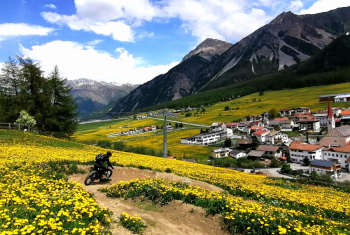
Beautiful tour along the entire Upper Venosta Valley. Mostly dirt roads and paved bike paths are followed, so the tour is also doable with gravel bikes. On a couple of occasions you descend into the valley along technical trails, but you can bypass them on forest roads.
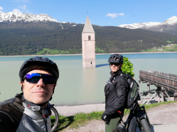
The views are fantastic, starting with the one over Lake Resia with the semi-submerged bell tower.

Very very enjoyable, although one must have a good workout for the many ups and downs and some particularly steep climbs. It is of course possible to split the tour into two parts or skip a section to shorten it.
Local weather
Tue 00:00

9 °C
Tue 12:00

12 °C
Wed 00:00

10 °C
Wed 12:00

12 °C
Thu 00:00

8 °C
Thu 12:00
10 °C
Graph
Nearest Routes

37,10 km
Km
+1 550 mt
Vertical meters
Route difficulty
Landscapes
20,14 km
Km
+1 072 mt
Vertical meters
Route difficulty
Landscapes
2023/07/18
- Italy - Trentino-Alto Adige/Südtirol, BZ 48,77 km
Km
+1 461 mt
Vertical meters
Route difficulty
Landscapes
85,80 km
Km
+2 800 mt
Vertical meters
Route difficulty
Landscapes
2026/08/20
- Italy - Trentino-Alto Adige/Südtirol, BZ 102,72 km
Km
+2 400 mt
Vertical meters
Route difficulty
Landscapes
77,02 km
Km
+3 100 mt
Vertical meters
Route difficulty
Landscapes
47,44 km
Km
+1 800 mt
Vertical meters
Route difficulty
Landscapes
2023/03/02
- Italy - Trentino-Alto Adige/Südtirol, BZ 40,98 km
Km
+1 980 mt
Vertical meters
Route difficulty
Landscapes
12,46 km
Km
+900 mt
Vertical meters
Route difficulty
Landscapes
84,83 km
Km
+2 050 mt
Vertical meters
Route difficulty
Landscapes