HOME RANKINGS CHALLENGES ROUTES NEAR ME PLANNING SEARCH LOGIN
Italy - Trentino-Alto Adige/Südtirol, BZ
2024/02/02 17:45:30

Rifugio Forcola e malga Stelvio sulla neve

2 Downloads
0
 
Share

Key Takeaways / Scheda Tecnica

Disciplina:
Mountain Bike (MTB)
Percorso:
Rifugio Forcola e malga Stelvio sulla neve
Località:
Italy - Trentino-Alto Adige/Südtirol, BZ
Distanza:
16,43 km
Dislivello Positivo:
+1 000 mt (Quota Min: 1702m - Max: 2155m)
Difficoltà Tecnica:
5/5
Valutazione Panorami:
5/5
Formato Traccia:
GPX Download disponibile
Author
nonnocarb
(324)
Place
Italy - Trentino-Alto Adige/Südtirol, BZ
Km
16,43 km
Elapsed time
00:00:00
Vertical meters
+1 000 mt (1702 - 2155)
Route difficulty
Landscapes
Last update
2024/02/03 12:04:45
Comments
0
Description

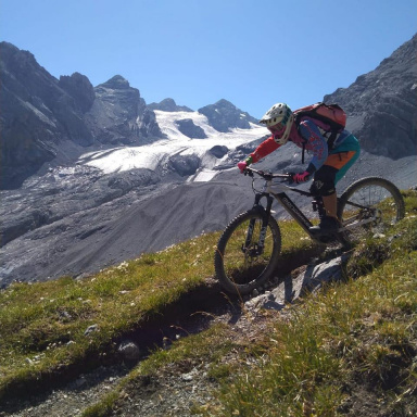
Itinerary on the #snow not easy, only for experts but very fun and with wonderful views to say the least.

Foto itinerario MTB Rifugio Forcola e malga Stelvio sulla neve - Italy - Trentino-Alto Adige/Südtirol, BZ

Fully rideable by ebike (depending on snow conditions) and with about half an hour pushing with fat bikes without motor. It is recommended to wait about two weeks after the last snowfall so that the trails are groomed.

Foto itinerario MTB Rifugio Forcola e malga Stelvio sulla neve - Italy - Trentino-Alto Adige/Südtirol, BZ

From the Fragges parking lot above the village of Stelvio, go up to the Forcola hut, climbing the forest road, usually beaten by snowshoes. As soon as you leave the forest fantastic views of Ortles and Stelvio. Descent where possible on the steepest path.

Foto itinerario MTB Rifugio Forcola e malga Stelvio sulla neve - Italy - Trentino-Alto Adige/Südtirol, BZ

Arrived at the bottom, climb on the path to the Stelvio hut, almost completely rideable by ebike. The lower part of the trail may be more or less snow-covered depending on conditions.

Foto itinerario MTB Rifugio Forcola e malga Stelvio sulla neve - Italy - Trentino-Alto Adige/Südtirol, BZ

You arrive at the Stelvio malga, which is very sunny, and return on the same trail. You can possibly return from the alpine hut trail after Stelvio hut, if this is well beaten.

Foto itinerario MTB Rifugio Forcola e malga Stelvio sulla neve - Italy - Trentino-Alto Adige/Südtirol, BZ

Download our free mobile app to send this route to your Garmin device or to navigate it on OSM maps. Android - iOS
Local weather
Tue 00:00
4 °C
Tue 12:00
6 °C
Wed 00:00
5 °C
Wed 12:00
7 °C
Thu 00:00
2 °C
Thu 12:00
2 °C
Fri 00:00
2 °C
Fri 12:00
5 °C
Sat 00:00
1 °C
Sat 12:00
1 °C

Graph

Nearest Routes

2023/03/05
- Italy - Trentino-Alto Adige/Südtirol, BZ
nonnocarb
(324)
37,16 km
Km
+1 730 mt
Vertical meters
Route difficulty
Landscapes
2024/09/11
- Italy - Trentino-Alto Adige/Südtirol, BZ
Staff
(110)
24,82 km
Km
+1 700 mt
Vertical meters
Route difficulty
Landscapes
2023/03/07
- Italy - Trentino-Alto Adige/Südtirol, BZ
nonnocarb
(324)
23,08 km
Km
+1 700 mt
Vertical meters
Route difficulty
Landscapes
2023/10/01
- Italy - Trentino-Alto Adige/Südtirol, BZ
Robibz
(25)
27,94 km
Km
+1 313 mt
Vertical meters
Route difficulty
Landscapes
2022/11/04
- Italy - Trentino-Alto Adige/Südtirol, BZ
nonnocarb
(324)
31,74 km
Km
+1 832 mt
Vertical meters
Route difficulty
Landscapes
2024/02/02
- Italy - Trentino-Alto Adige/Südtirol, BZ
nonnocarb
(324)
12,89 km
Km
+450 mt
Vertical meters
Route difficulty
Landscapes
2023/09/14
- Italy - Trentino-Alto Adige/Südtirol, BZ
makihl
(3)
51,99 km
Km
+2 400 mt
Vertical meters
Route difficulty
Landscapes
2023/03/06
- Italy - Trentino-Alto Adige/Südtirol, BZ
nonnocarb
(324)
47,44 km
Km
+1 800 mt
Vertical meters
Route difficulty
Landscapes
2023/09/27
- Italy - Trentino-Alto Adige/Südtirol, BZ
77,02 km
Km
+3 100 mt
Vertical meters
Route difficulty
Landscapes
2023/03/02
- Italy - Trentino-Alto Adige/Südtirol, BZ
nonnocarb
(324)
40,98 km
Km
+1 980 mt
Vertical meters
Route difficulty
Landscapes

0 Comments