HOME RANKINGS CHALLENGES ROUTES NEAR ME PLANNING SEARCH LOGIN
Italy - Trentino-Alto Adige/Südtirol, BZ
2026/08/27 12:27:02

Glorenza - Malga di Planol

0 Downloads
0
 
Share

Key Takeaways / Scheda Tecnica

Disciplina:
Mountain Bike (MTB)
Percorso:
Glorenza - Malga di Planol
Località:
Italy - Trentino-Alto Adige/Südtirol, BZ
Distanza:
37,10 km
Dislivello Positivo:
+1 550 mt (Quota Min: 914m - Max: 2199m)
Difficoltà Tecnica:
1/5
Valutazione Panorami:
4/5
Formato Traccia:
GPX Download disponibile
Author
Place
Italy - Trentino-Alto Adige/Südtirol, BZ
Km
37,10 km
Elapsed time
00:00:00
Vertical meters
+1 550 mt (914 - 2199)
Route difficulty
Landscapes
Last update
2026/08/28 08:02:39
Comments
0
Description

This tour starts in Glorenza and initially follows the Via Claudia Augusta bike path, passing through some of the picturesque villages of the Upper Venosta Valley, including Glorenza, Laudes, Clusio, and Burgusio, before heading toward the villages of Ultimo and Planol. From Glorenza, follow the bike path toward Laudes, passing through an area of apple orchards, meadows, and small historic villages. Once you reach the Burgusio area, the route continues north along the old country road to Planol. At the bridge before the Punihof farmstead, turn right and follow the signs.

From here, the forest roads begin to climb—quite steep in some sections—leading up the northern slope below the Spitzige Lun peak (2,324 meters). The narrow alpine pasture road winds through an uninhabited and wonderfully secluded valley, nestled in the natural beauty of the Upper Vinschgau Valley. After several challenging climbs, you’ll reach the Planol alpine pasture, where you can treat yourself to a well-deserved break with a traditional South Tyrolean snack. The local cheeses and products, along with the splendid view of the unspoiled natural landscape, more than make up for the effort of the climb.

For the return trip, follow the forest road toward Alsago, tackling a fairly steep descent down to the village. From there, take the paved road through Ultimo back toward Malles; turn left onto the forest road and climb again toward Malettes, then descend once more toward Malles and on to Glorenza, completing the tour.

This route combines the ease of the bike path along the Via Claudia Augusta with the more challenging climbs of the forest roads, offering spectacular views and an authentic taste of the Upper Val Venosta landscape.


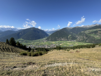
View from the Planol Alpine Pasture
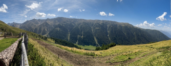
Foto itinerario MTB Glorenza - Malga di Planol - Italy - Trentino-Alto Adige/Südtirol, BZ


View from Malettes

Foto itinerario MTB Glorenza - Malga di Planol - Italy - Trentino-Alto Adige/Südtirol, BZ

Download our free mobile app to send this route to your Garmin device or to navigate it on OSM maps. Android - iOS
Local weather
Mar 00:00
9 °C
Mar 12:00
11 °C
Mer 00:00
10 °C
Mer 12:00
12 °C
Gio 00:00
8 °C
Gio 12:00
10 °C
Ven 00:00
6 °C
Ven 12:00
7 °C
Sab 00:00
6 °C
Sab 12:00
9 °C

Graph

Nearest Routes

2026/08/28
- Italy - Trentino-Alto Adige/Südtirol, BZ
20,14 km
Km
+1 072 mt
Vertical meters
Route difficulty
Landscapes
2023/03/04
- Italy - Trentino-Alto Adige/Südtirol, BZ
nonnocarb
(324)
85,06 km
Km
+2 720 mt
Vertical meters
Route difficulty
Landscapes
2023/07/18
- Italy - Trentino-Alto Adige/Südtirol, BZ
kcolrah
(5)
48,77 km
Km
+1 461 mt
Vertical meters
Route difficulty
Landscapes
2025/11/10
- Italy - Trentino-Alto Adige/Südtirol, BZ
nonnocarb
(324)
85,80 km
Km
+2 800 mt
Vertical meters
Route difficulty
Landscapes
2026/08/20
- Italy - Trentino-Alto Adige/Südtirol, BZ
nonnocarb
(324)
102,72 km
Km
+2 400 mt
Vertical meters
Route difficulty
Landscapes
2023/09/27
- Italy - Trentino-Alto Adige/Südtirol, BZ
77,02 km
Km
+3 100 mt
Vertical meters
Route difficulty
Landscapes
2023/03/06
- Italy - Trentino-Alto Adige/Südtirol, BZ
nonnocarb
(324)
47,44 km
Km
+1 800 mt
Vertical meters
Route difficulty
Landscapes
2023/02/26
- Italy - Trentino-Alto Adige/Südtirol, BZ
nonnocarb
(324)
12,46 km
Km
+900 mt
Vertical meters
Route difficulty
Landscapes
2023/03/02
- Italy - Trentino-Alto Adige/Südtirol, BZ
nonnocarb
(324)
40,98 km
Km
+1 980 mt
Vertical meters
Route difficulty
Landscapes
2023/03/04
- Italy - Trentino-Alto Adige/Südtirol, BZ
nonnocarb
(324)
84,83 km
Km
+2 050 mt
Vertical meters
Route difficulty
Landscapes

0 Comments