
 Italiano
 Deutsch
Corno Brunni 2862 Punta di Valrossa 2968
Short but intense itinerary, satisfying and not to be underestimated.
The Brunni Horn was missing from the Formazzina collection, urgently needed to fill the gap and why not by tackling it from its most hostile side. Free parking at the Toce waterfall lookout. At Riale just above water supply. Following the signs for Rif. Bin Se we pass it and at the dam take the orographic right side of Lake Morasco and at its end gain altitude with the dirt road that climbs to the Bettelmat plain. Before the overpass on the right we slip into another service road that with decided zig zags leads to the entrance of the ENI Gries tunnel. For now the pedaling is over.
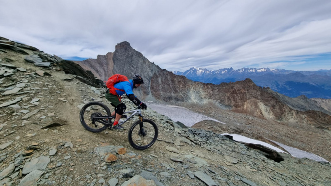
We carry ourselves over the entrance and aiming for the collar high above us we face a very challenging meadow wall. Zero trail , zero cairns, zero bolts. We then begin to traverse to the left with less slope and at the entrance of a wide gully we magically find a few cairns and a sketch of a trail. The stony terrain takes over and with alternating gradients we rise in increasingly grandiose surroundings.
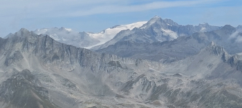
At the top of yet another promontory we land on the moon! Huge depression surrounded by vertical fine scree, paretone, spires, pinnacles, rocky overhead ridges and the sound of absolute silence. We rise again, reaching the edge of an agonizing glacier whose name I have no record of, and begin verticalizing again on decidedly challenging scree and boulders. Little cairns and other signs of passage have disappeared again, intuition or experience as it may be suggests pointing to the narrow saddle at the top left.Reached just beyond we can make out cairns and the ascent/descent path of the other side.
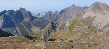
The trail is now well defined on very fine earth and scree and with ever steep gradient we reach the summit. Panorama as always fantastic, chamois and zero humans. Striking in the distance is the trail to Punta di Valrossa, it seems daring to do on foot let alone by bike. Yet. Meanwhile, let's enjoy the descent. Surprisingly despite the big incline and twisty sections it is all done on the bike with dry surfing and a bit of ignorance.
Just three penalties and a walking step. We reach the magnificent Lake Brunni nestled in its out-of-this-world basin and continue now on easier terrain, traverse at length on pleasant singletrack and descend until we intercept track that leads onto the main trail that climbs to Punta di Valrossa. Timid pedal, then push and finally portage. Once again we go from grasslands to scree, then to dirt and fine gravel on deadly slopes.
Second summit reached! If you avoid the most direct trail and ride wide zig zags you descend totally by bike to the col that leads onto the more vertical sections and even here the cyclability is absolute and sure fun.
We reach the scree slope that we tame without great fatigue but with sure fulfillment and finally on less challenging terrain we reach ref. MariaLuisa. Second descent 100% cyclable! From here on it is known history on the always rocky cuts towards Riale. It is recommended for the first ascent experience in moving on difficult terrain, to faithfully follow the gpx track if you are not familiar with the area and excellent downhill riding skills on very steep terrain.
 Itiner


