
 Italiano
 Deutsch
2025/11/21 09:40:01
Malga Naturno da Aschbach versione facile
Author

Place
Italy - Trentino-Alto Adige/Südtirol, BZ
Km
52,05 km
Elapsed time
04:44:02
Vertical meters
+1 750 mt (284 - 1956)
Route difficulty
Landscapes
Last update
2025/11/21 17:27:50
Comments
Hotels
Description
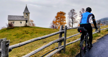
Challenging route due to elevation gain, but with beautiful views and no particular technical difficulties, also doable by gravel.
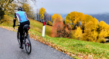
From Merano you climb to Tell and then to Aschbach. From here continue on forest road to Naturno alpine hut (refreshment).
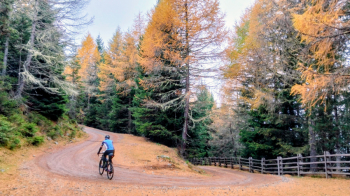
You descend to San Vigilio, Pavicolo and then Merano. From San Vigilio you can also descend to Merano on nice technical trail.
Local weather
Thu 00:00

21 °C
Thu 12:00

29 °C
Fri 00:00

25 °C
Fri 12:00
27 °C
Sat 00:00

23 °C
Sat 12:00
31 °C
Graph
Nearest Routes
107,50 km
Km
+2 800 mt
Vertical meters
Route difficulty
Landscapes
90,75 km
Km
+1 510 mt
Vertical meters
Route difficulty
Landscapes
53,14 km
Km
+1 900 mt
Vertical meters
Route difficulty
Landscapes
79,24 km
Km
+2 400 mt
Vertical meters
Route difficulty
Landscapes
2025/11/21
- Italy - Trentino-Alto Adige/Südtirol, BZ 66,02 km
Km
+2 000 mt
Vertical meters
Route difficulty
Landscapes
67,38 km
Km
+1 900 mt
Vertical meters
Route difficulty
Landscapes
49,70 km
Km
+1 600 mt
Vertical meters
Route difficulty
Landscapes
2024/09/18
- Italy - Trentino-Alto Adige/Südtirol, BZ 56,20 km
Km
+2 300 mt
Vertical meters
Route difficulty
Landscapes
71,62 km
Km
+1 820 mt
Vertical meters
Route difficulty
Landscapes
43,62 km
Km
+1 615 mt
Vertical meters
Route difficulty
Landscapes