HOME RANKINGS CHALLENGES ROUTES NEAR ME PLANNING SEARCH LOGIN
Italy - Trentino-Alto Adige/Südtirol, BZ
2023/03/04 20:54:24

Forcella del Santo in val Senales

6 Downloads
0
 
Share

Key Takeaways / Scheda Tecnica

Disciplina:
Mountain Bike (MTB)
Percorso:
Forcella del Santo in val Senales
Località:
Italy - Trentino-Alto Adige/Südtirol, BZ
Distanza:
107,50 km
Dislivello Positivo:
+2 800 mt (Quota Min: 300m - Max: 3110m)
Difficoltà Tecnica:
5/5
Valutazione Panorami:
5/5
Formato Traccia:
GPX Download disponibile
Author
nonnocarb
(324)
Place
Italy - Trentino-Alto Adige/Südtirol, BZ
Km
107,50 km
Elapsed time
-435005:-27:-24
Vertical meters
+2 800 mt (300 - 3110)
Route difficulty
Landscapes
Last update
2023/03/04 22:02:22
Comments
0
Description

Very hard and strenuous route, recommended only for bikers who like to carry their bikes on their backs for many hours.

Foto itinerario MTB Forcella del Santo in val Senales - Italy - Trentino-Alto Adige/Südtirol, BZ

On the other hand, the views are exceptional and the trails mildly enjoyable, though exposed and technical. From Merano you arrive at the parking lot at the base of the Juval (Messner) castle. You climb up the old Val Senales road, (forbidden due to rockfall, but doable).
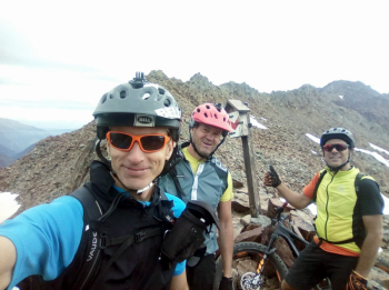
Foto itinerario MTB Forcella del Santo in val Senales - Italy - Trentino-Alto Adige/Südtirol, BZ

You then reach the top of the valley, pedal a little more, and then patiently push the bike for about 800 meters of elevation gain on steep trail. From the fork beautiful descent to the Mazia valley, watch out for snow still present in June but occasionally in July. At the bottom of the valley you return to the Venosta valley via forestry and trails. Last section on bike path.
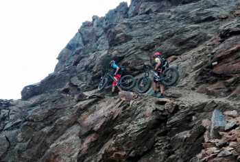
Foto itinerario MTB Forcella del Santo in val Senales - Italy - Trentino-Alto Adige/Südtirol, BZ

Download our free mobile app to send this route to your Garmin device or to navigate it on OSM maps. Android - iOS
Local weather
Tue 00:00
15 °C
Tue 12:00
18 °C
Wed 00:00
15 °C
Wed 12:00
14 °C
Thu 00:00
13 °C
Thu 12:00
15 °C
Fri 00:00
10 °C
Fri 12:00
12 °C
Sat 00:00
10 °C
Sat 12:00
13 °C

Graph

Nearest Routes

2025/11/21
- Italy - Trentino-Alto Adige/Südtirol, BZ
nonnocarb
(324)
52,05 km
Km
+1 750 mt
Vertical meters
Route difficulty
Landscapes
2023/03/04
- Italy - Trentino-Alto Adige/Südtirol, BZ
nonnocarb
(324)
90,75 km
Km
+1 510 mt
Vertical meters
Route difficulty
Landscapes
2025/11/21
- Italy - Trentino-Alto Adige/Südtirol, BZ
nonnocarb
(324)
53,14 km
Km
+1 900 mt
Vertical meters
Route difficulty
Landscapes
2025/11/16
- Italy - Trentino-Alto Adige/Südtirol, BZ
nonnocarb
(324)
79,24 km
Km
+2 400 mt
Vertical meters
Route difficulty
Landscapes
2023/03/04
- Italy - Trentino-Alto Adige/Südtirol, BZ
nonnocarb
(324)
49,70 km
Km
+1 600 mt
Vertical meters
Route difficulty
Landscapes
2025/11/21
- Italy - Trentino-Alto Adige/Südtirol, BZ
nonnocarb
(324)
66,02 km
Km
+2 000 mt
Vertical meters
Route difficulty
Landscapes
2024/11/18
- Italy - Trentino-Alto Adige/Südtirol, BZ
nonnocarb
(324)
67,38 km
Km
+1 900 mt
Vertical meters
Route difficulty
Landscapes
2024/09/18
- Italy - Trentino-Alto Adige/Südtirol, BZ
nonnocarb
(324)
56,20 km
Km
+2 300 mt
Vertical meters
Route difficulty
Landscapes
2023/03/04
- Italy - Trentino-Alto Adige/Südtirol, BZ
nonnocarb
(324)
71,62 km
Km
+1 820 mt
Vertical meters
Route difficulty
Landscapes
2023/03/01
- Italy - Trentino-Alto Adige/Südtirol, BZ
nonnocarb
(324)
43,62 km
Km
+1 615 mt
Vertical meters
Route difficulty
Landscapes

0 Comments