HOME RANKINGS CHALLENGES ROUTES NEAR ME PLANNING SEARCH LOGIN
Italy - Trentino-Alto Adige/Südtirol, BZ
2025/11/21 09:06:33

Mairalm in val Senales versione facile

3 Downloads
0
 
Share

Key Takeaways / Scheda Tecnica

Disciplina:
Mountain Bike (MTB)
Percorso:
Mairalm in val Senales versione facile
Località:
Italy - Trentino-Alto Adige/Südtirol, BZ
Distanza:
66,02 km
Dislivello Positivo:
+2 000 mt (Quota Min: 280m - Max: 2111m)
Difficoltà Tecnica:
1/5
Valutazione Panorami:
4/5
Formato Traccia:
GPX Download disponibile
Author
nonnocarb
(324)
Place
Italy - Trentino-Alto Adige/Südtirol, BZ
Km
66,02 km
Elapsed time
04:52:40
Vertical meters
+2 000 mt (280 - 2111)
Route difficulty
Landscapes
Last update
2025/11/21 09:16:14
Comments
0
Description

Challenging route in terms of length and elevation gain, but without any technical difficulties, also doable by gravel, except for a somewhat technical section of flat trail, but at most it's a 5-10 minute walk.
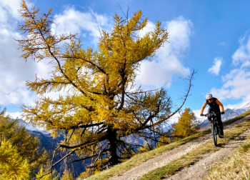
Foto itinerario MTB Mairalm in val Senales versione facile - Italy - Trentino-Alto Adige/Südtirol, BZ

From Merano you reach Naturno on a bike path, then climb to the Lint farm (refreshment), with splendid views of the Vinschgau valley. From here a steep uphill and then downhill forest road begins.
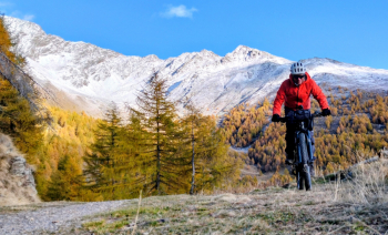
Foto itinerario MTB Mairalm in val Senales versione facile - Italy - Trentino-Alto Adige/Südtirol, BZ

Then climb to the Dicker farm (refreshment) in the larch forest and with beautiful views of the Schnalstal valley.
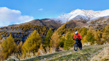
Foto itinerario MTB Mairalm in val Senales versione facile - Italy - Trentino-Alto Adige/Südtirol, BZ

From here short trail to the Mairalm (refreshment). The classic route involves descending on a challenging trail, instead this variant continues on the forest road with beautiful views down to Mount St. Catherine and then Naturno
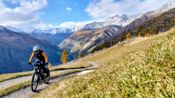
Foto itinerario MTB Mairalm in val Senales versione facile - Italy - Trentino-Alto Adige/Südtirol, BZ

Download our free mobile app to send this route to your Garmin device or to navigate it on OSM maps. Android - iOS
Local weather
Tue 00:00
15 °C
Tue 12:00
17 °C
Wed 00:00
15 °C
Wed 12:00
14 °C
Thu 00:00
13 °C
Thu 12:00
15 °C
Fri 00:00
10 °C
Fri 12:00
12 °C
Sat 00:00
10 °C
Sat 12:00
13 °C

Graph

Nearest Routes

2024/11/18
- Italy - Trentino-Alto Adige/Südtirol, BZ
nonnocarb
(324)
67,38 km
Km
+1 900 mt
Vertical meters
Route difficulty
Landscapes
2023/02/26
- Italy - Trentino-Alto Adige/Südtirol, BZ
nonnocarb
(324)
36,78 km
Km
+1 610 mt
Vertical meters
Route difficulty
Landscapes
2023/03/04
- Italy - Trentino-Alto Adige/Südtirol, BZ
nonnocarb
(324)
58,50 km
Km
+1 370 mt
Vertical meters
Route difficulty
Landscapes
2023/03/05
- Italy - Trentino-Alto Adige/Südtirol, BZ
nonnocarb
(324)
85,71 km
Km
+2 730 mt
Vertical meters
Route difficulty
Landscapes
2023/03/01
- Italy - Trentino-Alto Adige/Südtirol, BZ
nonnocarb
(324)
43,62 km
Km
+1 615 mt
Vertical meters
Route difficulty
Landscapes
2024/07/26
- Italy - Trentino-Alto Adige/Südtirol, BZ
nonnocarb
(324)
64,32 km
Km
+2 400 mt
Vertical meters
Route difficulty
Landscapes
2023/03/04
- Italy - Trentino-Alto Adige/Südtirol, BZ
nonnocarb
(324)
71,35 km
Km
+1 830 mt
Vertical meters
Route difficulty
Landscapes
2022/10/28
- Italy - Trentino-Alto Adige/Südtirol, BZ
nonnocarb
(324)
52,87 km
Km
+1 754 mt
Vertical meters
Route difficulty
Landscapes
2023/03/04
- Italy - Trentino-Alto Adige/Südtirol, BZ
nonnocarb
(324)
58,93 km
Km
+3 000 mt
Vertical meters
Route difficulty
Landscapes
2022/11/01
- Italy - Trentino-Alto Adige/Südtirol, BZ
nonnocarb
(324)
42,55 km
Km
+2 157 mt
Vertical meters
Route difficulty
Landscapes

0 Comments