HOME RANKINGS CHALLENGES ROUTES NEAR ME PLANNING SEARCH LOGIN
Italy - Trentino-Alto Adige/Südtirol, BZ
2023/03/06 20:54:14

Val di Roja e cima Pian dei Laghi

28 Downloads
2
 
Share

Key Takeaways / Scheda Tecnica

Disciplina:
Mountain Bike (MTB)
Percorso:
Val di Roja e cima Pian dei Laghi
Località:
Italy - Trentino-Alto Adige/Südtirol, BZ
Distanza:
31,43 km
Dislivello Positivo:
+1 420 mt (Quota Min: 1445m - Max: 2829m)
Difficoltà Tecnica:
5/5
Valutazione Panorami:
4/5
Formato Traccia:
GPX Download disponibile
Author
nonnocarb
(324)
Place
Italy - Trentino-Alto Adige/Südtirol, BZ
Km
31,43 km
Elapsed time
06:54:00
Vertical meters
+1 420 mt (1445 - 2829)
Route difficulty
Landscapes
Last update
2023/03/07 14:18:24
Comments
0
Description

Very challenging itinerary discovering the wild Roja valley above Lake Resia, both for the long ascent that also requires many stretches of backpacking bikes, and for the technical downhill trails. Exceptional views of Lake Resia, the Austrian Alps and Similaun, and the beautiful Roja valley.

Foto itinerario MTB Val di Roja e cima Pian dei Laghi - Italy - Trentino-Alto Adige/Südtirol, BZ

From the Muta Lake you climb to Resia Lake and then to the start of the Belpiano lifts. You then enter the Roja valley road and eventually push about 200 meters in elevation gain to the ridge. From here a pedaled section and then again by bike with some challenging sections up to the cross of Pian dei Laghi - Seebodenspitz with beautiful views.
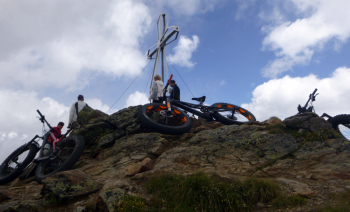
Foto itinerario MTB Val di Roja e cima Pian dei Laghi - Italy - Trentino-Alto Adige/Südtirol, BZ

From here descend on nice trail with technical sections to the Haideralm (refreshment), then a pedaled section with slight ascent and last nice downhill trail to the lake.Foto itinerario MTB Val di Roja e cima Pian dei Laghi - Italy - Trentino-Alto Adige/Südtirol, BZ

Download our free mobile app to send this route to your Garmin device or to navigate it on OSM maps. Android - iOS
Local weather
Tue 00:00
5 °C
Tue 12:00
10 °C
Wed 00:00
8 °C
Wed 12:00
10 °C
Thu 00:00
4 °C
Thu 12:00
6 °C
Fri 00:00
3 °C
Fri 12:00
6 °C
Sat 00:00
2 °C
Sat 12:00
5 °C

Graph

Nearest Routes

2023/02/26
- Italy - Trentino-Alto Adige/Südtirol, BZ
nonnocarb
(324)
36,98 km
Km
+800 mt
Vertical meters
Route difficulty
Landscapes
2023/02/26
- Italy - Trentino-Alto Adige/Südtirol, BZ
nonnocarb
(324)
32,12 km
Km
+876 mt
Vertical meters
Route difficulty
Landscapes
2023/07/03
- Italy - Trentino-Alto Adige/Südtirol, BZ
@ff.mtb
(9)
62,82 km
Km
+2 000 mt
Vertical meters
Route difficulty
Landscapes
2024/02/02
- Italy - Trentino-Alto Adige/Südtirol, BZ
nonnocarb
(324)
26,70 km
Km
+600 mt
Vertical meters
Route difficulty
Landscapes
2023/02/26
- Italy - Trentino-Alto Adige/Südtirol, BZ
nonnocarb
(324)
12,46 km
Km
+900 mt
Vertical meters
Route difficulty
Landscapes
2026/08/20
- Italy - Trentino-Alto Adige/Südtirol, BZ
nonnocarb
(324)
102,72 km
Km
+2 400 mt
Vertical meters
Route difficulty
Landscapes
2025/11/10
- Italy - Trentino-Alto Adige/Südtirol, BZ
nonnocarb
(324)
85,80 km
Km
+2 800 mt
Vertical meters
Route difficulty
Landscapes
2023/07/18
- Italy - Trentino-Alto Adige/Südtirol, BZ
kcolrah
(5)
48,77 km
Km
+1 461 mt
Vertical meters
Route difficulty
Landscapes
2026/08/27
- Italy - Trentino-Alto Adige/Südtirol, BZ
37,10 km
Km
+1 550 mt
Vertical meters
Route difficulty
Landscapes
2026/08/28
- Italy - Trentino-Alto Adige/Südtirol, BZ
20,14 km
Km
+1 072 mt
Vertical meters
Route difficulty
Landscapes

0 Comments