HOME RANKINGS CHALLENGES ROUTES NEAR ME PLANNING SEARCH LOGIN
Italy - Toscana, PO
2025/10/04 16:25:29

Luciana - Lupin - Lucky Luciana

5 Downloads
0
 
Share

Key Takeaways / Scheda Tecnica

Disciplina:
Mountain Bike (MTB)
Percorso:
Luciana - Lupin - Lucky Luciana
Località:
Italy - Toscana, PO
Distanza:
27,05 km
Dislivello Positivo:
+1 396 mt (Quota Min: 500m - Max: 1122m)
Difficoltà Tecnica:
3/5
Valutazione Panorami:
5/5
Formato Traccia:
GPX Download disponibile
Author
Place
Italy - Toscana, PO
Km
27,05 km
Elapsed time
03:28:24
Vertical meters
+1 396 mt (500 - 1122)
Route difficulty
Landscapes
Last update
2025/10/04 16:28:17
Comments
0
Description

Nice all mountain ride in the upper Bisenzio valley in Prato especially in the summer time. Departing from the village of Luciana, we climb for about an hour on a paved road, cars are very scarce, to the junction to head towards the Poggio di Petto refuge. We climb until we reach the cross of the homonymous knoll, which deserves a stop to enjoy the panorama that sweeps over the whole area, then turn back to go to take path 00 to the junction with 425 taken which we continue a long traverse until we find the beginning of the well-marked Lupin trail.

Kudos to the guys in Vernio, great job, and here between boulders jumps bends there is fun to be had until returning very close to Luciana. I returned to the refuge of Poggio di Petto but this time I took trail 456, called Lucky Luciana, to descend. This is a Cai trail so very natural, narrow in many places, sharp bends, loose stones etc.etc. very nice and a nice viewpoint over the Carigiola valley. The trail goes all the way to the village of Luciana.
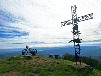
Foto itinerario MTB Luciana - Lupin - Lucky Luciana - Italy - Toscana, PO

Download our free mobile app to send this route to your Garmin device or to navigate it on OSM maps. Android - iOS
Local weather
Tue 00:00
12 °C
Tue 12:00
18 °C
Wed 00:00
15 °C
Wed 12:00
16 °C
Thu 00:00
13 °C
Thu 12:00
16 °C
Fri 00:00
8 °C
Fri 12:00
14 °C
Sat 00:00
12 °C
Sat 12:00
12 °C

Graph

Nearest Routes

2026/05/05
- Italy - Emilia-Romagna, BO
ebsat
(129)
35,52 km
Km
+1 706 mt
Vertical meters
Route difficulty
Landscapes
2025/10/14
- Italy - Emilia-Romagna, BO
ebsat
(129)
30,42 km
Km
+1 509 mt
Vertical meters
Route difficulty
Landscapes
61,42 km
Km
+1 740 mt
Vertical meters
Route difficulty
Landscapes
2024/05/27
- Italy - Toscana, PT
Paoloc1
(135)
43,20 km
Km
+1 200 mt
Vertical meters
Route difficulty
Landscapes
2024/08/12
- Italy - Emilia-Romagna, BO
18,11 km
Km
+718 mt
Vertical meters
Route difficulty
Landscapes
2023/03/01
- Italy - Toscana, FI
Nikfab
(14)
43,30 km
Km
+1 880 mt
Vertical meters
Route difficulty
Landscapes
2023/03/01
- Italy - Toscana, PT
Nikfab
(14)
31,30 km
Km
+1 340 mt
Vertical meters
Route difficulty
Landscapes
2023/02/19
- Italy - Toscana, PO
ebsat
(129)
31,20 km
Km
+1 197 mt
Vertical meters
Route difficulty
Landscapes
2023/03/05
- Italy - Toscana, FI
nonnocarb
(324)
34,85 km
Km
+1 150 mt
Vertical meters
Route difficulty
Landscapes
2023/12/07
- Italy - Emilia-Romagna, BO
23,11 km
Km
+570 mt
Vertical meters
Route difficulty
Landscapes

0 Comments