
 Italiano
 Deutsch
2023/03/01 20:58:15
Anello dalle Croci alla Rocca di Cerbaia
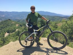
Author
Place
Italy - Toscana, FI
Km
43,30 km
Elapsed time
05:24:53
Vertical meters
+1 880 mt (194 - 937)
Route difficulty
Landscapes
Last update
2023/03/02 08:01:53
Comments
Hotels
Description
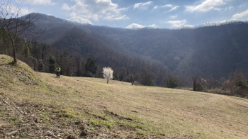
Beautiful loop for single track lovers.
Departure from the Croci di Calenzano climb up to Monte Maggiore and continue along the ridge to Masso di Costa where you detour to descend first to Montecuccoli and then via a nice stretch to Rocca di Cerbaia, from here climb back up to Montecuccoli and then passing by Agriturismi S. Stefano and Borgo Tutto è Vita climb through mostly via single track to Valibona and then return to the start.
Local weather
Fri 00:00

24 °C
Fri 12:00
31 °C
Sat 00:00
22 °C
Sat 12:00

29 °C
Sun 00:00
23 °C
Sun 12:00
28 °C


Graph
Nearest Routes
22,01 km
Km
+998 mt
Vertical meters
Route difficulty
Landscapes
44,16 km
Km
+1 370 mt
Vertical meters
Route difficulty
Landscapes
40,39 km
Km
+1 800 mt
Vertical meters
Route difficulty
Landscapes
31,20 km
Km
+1 500 mt
Vertical meters
Route difficulty
Landscapes
36,45 km
Km
+1 460 mt
Vertical meters
Route difficulty
Landscapes
34,21 km
Km
+1 400 mt
Vertical meters
Route difficulty
Landscapes
31,67 km
Km
+1 260 mt
Vertical meters
Route difficulty
Landscapes
31,20 km
Km
+1 197 mt
Vertical meters
Route difficulty
Landscapes
48,96 km
Km
+2 100 mt
Vertical meters
Route difficulty
Landscapes
35,53 km
Km
+1 600 mt
Vertical meters
Route difficulty
Landscapes