HOME RANKINGS CHALLENGES ROUTES NEAR ME PLANNING SEARCH LOGIN
Italy - Trentino-Alto Adige/Südtirol, BZ
2024/02/02 18:03:16

Plamort e lago di Resia sulla neve

12 Downloads
0
 
Share

Key Takeaways / Scheda Tecnica

Disciplina:
Mountain Bike (MTB)
Percorso:
Plamort e lago di Resia sulla neve
Località:
Italy - Trentino-Alto Adige/Südtirol, BZ
Distanza:
26,70 km
Dislivello Positivo:
+600 mt (Quota Min: 1405m - Max: 2060m)
Difficoltà Tecnica:
5/5
Valutazione Panorami:
5/5
Formato Traccia:
GPX Download disponibile
Author
nonnocarb
(324)
Place
Italy - Trentino-Alto Adige/Südtirol, BZ
Km
26,70 km
Elapsed time
04:28:53
Vertical meters
+600 mt (1405 - 2060)
Route difficulty
Landscapes
Last update
2024/02/03 12:06:05
Comments
0
Description

Itinerary not very long but very enjoyable and scenic.
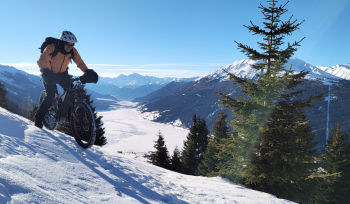
Foto itinerario MTB Plamort e lago di Resia sulla neve - Italy - Trentino-Alto Adige/Südtirol, BZ

It can be done the same way in both summer and winter. You start at the Resia Lake dam and follow the snowy bike path on the orographic right side. At the village of Resia you go uphill and reach the source of the Adige River.
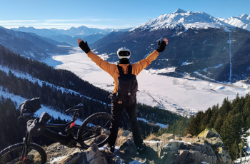
Foto itinerario MTB Plamort e lago di Resia sulla neve - Italy - Trentino-Alto Adige/Südtirol, BZ

You then climb on forestry beaten by the snowcat until you reach Plamort, with a stupendous viewpoint over the lake. Continue on and you reach the border with Austria, where we find the famous dragon's teeth, the World War II anti-panzer barrage.
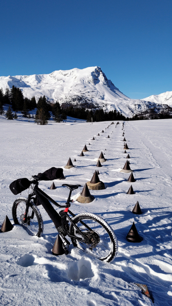
Foto itinerario MTB Plamort e lago di Resia sulla neve - Italy - Trentino-Alto Adige/Südtirol, BZ

This is the less traveled section; there is usually a trail beaten by snowshoers. You then descend to Resia along the fun snowy trail and continue to the semi-submerged bell tower. If the lake is well frozen you can ride on the ice, especially if you have studded tires.
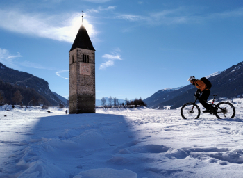
Foto itinerario MTB Plamort e lago di Resia sulla neve - Italy - Trentino-Alto Adige/Südtirol, BZ

From here you continue along the snowy road to the dam.
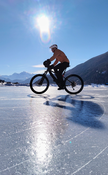
Foto itinerario MTB Plamort e lago di Resia sulla neve - Italy - Trentino-Alto Adige/Südtirol, BZ

#snow

Download our free mobile app to send this route to your Garmin device or to navigate it on OSM maps. Android - iOS
Local weather
Tue 00:00
9 °C
Tue 12:00
11 °C
Wed 00:00
8 °C
Wed 12:00
11 °C
Thu 00:00
2 °C
Thu 12:00
4 °C
Fri 00:00
3 °C
Fri 12:00
5 °C
Sat 00:00
3 °C
Sat 12:00
3 °C

Graph

Nearest Routes

2023/07/03
- Italy - Trentino-Alto Adige/Südtirol, BZ
@ff.mtb
(9)
62,82 km
Km
+2 000 mt
Vertical meters
Route difficulty
Landscapes
2023/02/26
- Italy - Trentino-Alto Adige/Südtirol, BZ
nonnocarb
(324)
32,12 km
Km
+876 mt
Vertical meters
Route difficulty
Landscapes
2023/02/26
- Italy - Trentino-Alto Adige/Südtirol, BZ
nonnocarb
(324)
36,98 km
Km
+800 mt
Vertical meters
Route difficulty
Landscapes
2023/03/06
- Italy - Trentino-Alto Adige/Südtirol, BZ
nonnocarb
(324)
31,43 km
Km
+1 420 mt
Vertical meters
Route difficulty
Landscapes
2023/02/26
- Italy - Trentino-Alto Adige/Südtirol, BZ
nonnocarb
(324)
12,46 km
Km
+900 mt
Vertical meters
Route difficulty
Landscapes
2025/02/05
- Italy - Trentino-Alto Adige/Südtirol, BZ
nonnocarb
(324)
37,41 km
Km
+1 400 mt
Vertical meters
Route difficulty
Landscapes
2026/08/20
- Italy - Trentino-Alto Adige/Südtirol, BZ
nonnocarb
(324)
102,72 km
Km
+2 400 mt
Vertical meters
Route difficulty
Landscapes
2023/02/26
- Italy - Trentino-Alto Adige/Südtirol, BZ
nonnocarb
(324)
31,06 km
Km
+1 120 mt
Vertical meters
Route difficulty
Landscapes
2025/11/10
- Italy - Trentino-Alto Adige/Südtirol, BZ
nonnocarb
(324)
85,80 km
Km
+2 800 mt
Vertical meters
Route difficulty
Landscapes
2023/07/18
- Italy - Trentino-Alto Adige/Südtirol, BZ
kcolrah
(5)
48,77 km
Km
+1 461 mt
Vertical meters
Route difficulty
Landscapes

0 Comments