
 Italiano
 Deutsch
2023/02/06 18:11:57
Monte Roen invernale
Author

Place
Italy - Trentino-Alto Adige/Südtirol, TN
Km
17,43 km
Elapsed time
03:24:00
Vertical meters
+751 mt (1346 - 2114)
Route difficulty
Landscapes
Last update
2023/02/06 19:00:14
Comments
Hotels
Description
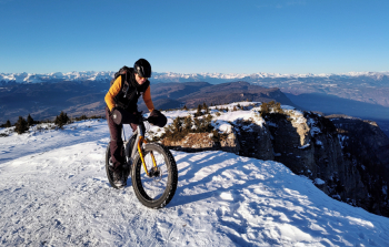
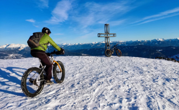
Winter itinerary, all on snow, not very long but rather challenging and with amazing views from the summit.
From the Mendola pass you follow senpre the path 500, which is a comfortable snowy forest road, with some hard climbs, to the Romeno hut
From here, if the snow is a bit old and well beaten by hikers, by ebike you can pedal all the way to the top, while by regular bike you have to push, because of the steep slopes, about half an hour, with only a few pedaled sections.
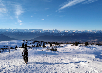
From the summit fantastic 360-degree views of much of Trentino Alto Adige. It is recommended to do the hike at least 10 days after the last snowfall, in good weather and in the absence of strong wind, which beats a lot up there! Very fun descent on the same trail.
Local weather
Thu 00:00

16 °C
Thu 12:00

21 °C
Fri 00:00

18 °C
Fri 12:00

19 °C
Sat 00:00
17 °C
Sat 12:00
23 °C
Graph
Nearest Routes
30,38 km
Km
+1 600 mt
Vertical meters
Route difficulty
Landscapes
64,40 km
Km
+2 400 mt
Vertical meters
Route difficulty
Landscapes
50,17 km
Km
+1 000 mt
Vertical meters
Route difficulty
Landscapes
26,96 km
Km
+1 300 mt
Vertical meters
Route difficulty
Landscapes
59,06 km
Km
+2 100 mt
Vertical meters
Route difficulty
Landscapes
92,88 km
Km
+4 200 mt
Vertical meters
Route difficulty
Landscapes
42,74 km
Km
+1 300 mt
Vertical meters
Route difficulty
Landscapes
24,25 km
Km
+1 389 mt
Vertical meters
Route difficulty
Landscapes
21,72 km
Km
+880 mt
Vertical meters
Route difficulty
Landscapes
63,83 km
Km
+1 220 mt
Vertical meters
Route difficulty
Landscapes