HOME RANKINGS CHALLENGES ROUTES NEAR ME PLANNING SEARCH LOGIN
Italy - Trentino-Alto Adige/Südtirol, BZ
2023/02/26 11:07:14

Monte Macaion sulla neve

1 Downloads
0
 
Share
Author
nonnocarb
(292)
Place
Italy - Trentino-Alto Adige/Südtirol, BZ
Km
21,72 km
Elapsed time
04:08:38
Vertical meters
+880 mt (1380 - 1860)
Route difficulty
Landscapes
Last update
2023/12/04 13:55:12
Comments
0
Description

Beautiful route on the #snow, although very challenging for the ascent to Macaion. Very difficult to do if there is a lot of snow and fresh, instead at certain times, like in January 2023, the snow is now old and very beaten by the passage of snowshoers, so the trail is all passable. Ideal by e-fat bike, as some of the climbs are very steep, but it can also be done by regular fat bike with a few more pushing sections.
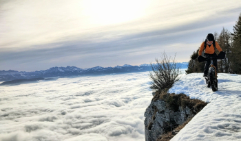
From the parking lot you arrive on snow-covered forestry to Tret Lake. From here a partly challenging trail starts that leads to the forest road that climbs to Macaion. If the forest road is beaten you can follow it, but usually you have to follow the track on the trail, with some pushing to the top of Macaion. From here incredible views of the entire Adige Valley from Merano to Bolzano and the Dolomites.

You descend on the fun trail (with ascent) to the lake and then take trail 500, also beaten only by snowshoes, to the Schoenegg cross, with beautiful panoramic views.

From here, still on snow-covered trail, return to the parking lot.

Caution, venture on snowshoe trails only if equipped with excellent driving technique!

Download our free mobile app to send this route to your Garmin device or to navigate it on OSM maps. Android - iOS
Local weather
°C
°C
°C
°C
°C
°C
°C
°C
°C
°C

Graph

Nearest Routes

2023/02/26
- Italy - Trentino-Alto Adige/Südtirol, BZ
nonnocarb
(292)
26,94 km
Km
+1 020 mt
Vertical meters
Route difficulty
Landscapes
2023/05/25
- Italy - Trentino-Alto Adige/Südtirol, BZ
steve-U
(23)
31,85 km
Km
+1 829 mt
Vertical meters
Route difficulty
Landscapes
2023/03/07
- Italy - Trentino-Alto Adige/Südtirol, BZ
nonnocarb
(292)
41,08 km
Km
+1 500 mt
Vertical meters
Route difficulty
Landscapes
2023/02/06
- Italy - Trentino-Alto Adige/Südtirol, TN
nonnocarb
(292)
17,43 km
Km
+751 mt
Vertical meters
Route difficulty
Landscapes
2023/03/05
- Italy - Trentino-Alto Adige/Südtirol, BZ
nonnocarb
(292)
48,31 km
Km
+760 mt
Vertical meters
Route difficulty
Landscapes
2023/04/10
- Italy - Trentino-Alto Adige/Südtirol, BZ
steve-U
(23)
21,43 km
Km
+1 028 mt
Vertical meters
Route difficulty
Landscapes
2023/04/08
- Italy - Trentino-Alto Adige/Südtirol, BZ
26,96 km
Km
+1 300 mt
Vertical meters
Route difficulty
Landscapes
2023/08/07
- Italy - Trentino-Alto Adige/Südtirol, BZ
Simo rad
(1)
65,12 km
Km
+2 370 mt
Vertical meters
Route difficulty
Landscapes
2023/05/22
- Italy - Trentino-Alto Adige/Südtirol, BZ
Robibz
(19)
43,62 km
Km
+1 392 mt
Vertical meters
Route difficulty
Landscapes
2023/03/05
- Italy - Trentino-Alto Adige/Südtirol, BZ
nonnocarb
(292)
40,59 km
Km
+770 mt
Vertical meters
Route difficulty
Landscapes

0 Comments