Italiano
 Deutsch
Cabianca versione monte dei Frati

This is the longest, most scenic, and most comprehensive version of the Cabianca loop—a decidedly mountaineering-oriented variation of the classic Twin Lakes loop that takes you through some of the most spectacular areas of the upper Val Brembana. Compared to the more direct route starting from Carona, here we deliberately choose to extend the route: the route starts in the Branzi/Cagnoli area, climbs toward the Calvi Mountain Hut, passes by Lago dei Curiosi, and reaches Cabianca via a long portage section in a high-mountain setting. Even after Cabianca, the route maintains its high-altitude philosophy: instead of immediately descending toward Lago di Aviasco, you stay on the ridge, passing beneath Monte Varrozza and continuing toward Monte dei Frati. This is probably the most beautiful version of the route, but also one of the most challenging among the proposed trails. The key section remains the Cabianca ridge crossing, which is extremely exposed and resembles T5 hiking terrain. Added to this are extensive portage sections, an S5 descent from Monte dei Frati, and a long final descent toward Branzi. E-MTBs are strongly discouraged: on this route, the extra weight would become a serious problem during the portage and especially on the ridge sections, where you need to have as much control over the bike as possible.
SPOILER: Of the two versions of the Cabianca, this one is, in my opinion, the most beautiful.
From Branzi to the Calvi Mountain Hut
The route starts in the Branzi/Cagnoli area and begins the long climb toward the Calvi area. This choice significantly increases the distance and elevation gain compared to starting from Carona, but it allows you to create a complete loop that ends back in Branzi. The first part, however, is the day’s longest rideable stretch. The gradients are steep and the climb is long, but you manage to gain a significant amount of elevation while in the saddle. You continue toward the Carona area and then along the classic climb leading to the Calvi Mountain Hut. You’ll need to manage your energy carefully: everything you gain by pedaling in this first section will be needed later on, when you’ll be carrying your bike on your shoulders for quite some time.
Calvi Mountain Hut and Lago dei Curiosi
Once you reach the Rifugio Calvi area, instead of taking the shortest route to Cabianca, continue toward Lago dei Curiosi. This choice adds distance and elevation gain, but makes this route far more scenic and complete. From Lago dei Curiosi, the character of the ride changes completely. The rideable sections practically disappear, and the long approach on foot toward Cabianca begins. You’ll proceed over increasingly rocky terrain, following a trail that isn’t particularly obvious in some places. The environment becomes progressively harsher and more isolated, and you need to be accustomed to reading the terrain even when the trail isn’t immediately recognizable.
The final 400 meters toward Cabianca
As you approach an elevation of 2,500 m, the climb becomes significantly more challenging. The final 400 meters or so of elevation gain are a true alpine portage section: rocks, loose soil, steep slopes, and several spots where you must carefully choose your footing. The effort no longer comes solely from the weight of the bike. You need to move skillfully over unstable terrain, maintaining balance and control while carrying the MTB. This is already a very challenging section, but the main difficulty comes just before reaching the upper part of Cabianca.
Cabianca Ridge, Extreme Passage
Here, the difficulty of the route increases even further. You reach a narrow, highly exposed ridge, with conditions that can be considered close to a T5 hiking grade. It’s not your typical narrow trail where all you need is a bit of caution. At one point, the ridge becomes so sharp that the most natural way to cross it is practically straddling it, with one leg on one side and the other on the other. The most delicate section is concentrated within a few meters, and the most extreme point measures approximately two meters. Viewed from a distance, it may seem almost impossible. Once you reach it, however, by carefully observing the footholds and the rock’s contours, the movement becomes clearer. This, however, should not lead you to underestimate it: the exposure remains very high, and at the same time, you must control your mountain bike. There are no chains or ropes here to provide a safety anchor. You must therefore be completely comfortable with heights and have great confidence in your movements on alpine terrain. If, upon arriving at the spot, you do not feel completely confident, turn back. This is not a section where you should test the limits of your abilities. Once past the ridge, you finally reach the upper section of Mount Cabianca.
Descent from Cabianca S4/S4+
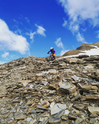
After all that portage, you’re finally back in the saddle. The first roughly 100 meters of descent offer a beautiful technical ride on alpine terrain, roughly full S4 with a few S4+ sections. It’s technical and requires attention, but it’s definitely more manageable than the challenges faced just before on foot. A short section follows where you’ll need to carry your bike again. From here, instead of descending toward Lake Aviasco, this trail takes the more interesting route: it stays at a higher elevation.
Ridge toward Monte Varrozza and Monte dei Frati
Continue along the ridge, passing beneath Monte Varrozza and heading toward Monte dei Frati. This is one of the most beautiful sections of the entire route. After the challenging passage at Cabianca, the ridge becomes much easier to navigate and allows you to proceed through spectacular scenery without encountering difficulties comparable to those just overcome. You remain at high elevation throughout, with wide-open views and the feeling of a high-mountain route—which is likely the true added value of this variant. Just before Monte dei Frati, however, there is a 1–2-meter drop where you’ll need to lower your bike. This section is much easier to manage if there are at least two of you, so you can descend separately and then pass the MTB to each other. Once past this point, you’ll reach the Monte dei Frati area.
Descent from Monte dei Frati S5
From here, another key section of the ride begins. Over a vertical drop of about 150 meters—roughly from an elevation of 2,450 to 2,300 meters—the trail descends very steeply with an S5 difficulty rating. It is a vertical, technical, and demanding descent, intended only for riders who truly possess the necessary skill level. You don’t have to try to ride the entire section: assess each section carefully and decide on a case-by-case basis what you’re comfortable tackling. Once past this section, the difficulty gradually becomes more manageable, and the route continues toward the Passo di Aviasco area.
Aviasco Pass – Lake Colombo
From the Aviasco Pass, you’ll enter a very scenic trail that descends toward Lake Colombo. After the most challenging section of Monte dei Frati, the ride finally becomes more controlled and continuous. You’ll reach Lake Colombo and from there continue on the long descent toward Lake Pian delle Casere. The difficulty of this section is roughly S2/S3, with a few more technical sections, but overall it allows you to regain energy and let the bike roll more freely. After many hours spent carrying the bike, traversing ridges, and tackling technical descents, this is a decidedly more relaxing and very enjoyable part of the ride.
Descent toward Branzi CAI 212
From Pian delle Casere, you then take CAI 212 toward Branzi. It’s one of the classic and most interesting descents in the area and provides a great way to wrap up an already extremely well-rounded ride. The first section alternates between S3 and S4 difficulty, with numerous technical sections that are generally manageable for riders who have reached this point with the necessary skill level. As you descend, the trail remains technical and fun, becoming more challenging again toward the end. Here you’ll find a full S4 section, with some passages that can reach S5. It’s therefore a long and well-rounded descent, but compared to the 211 trail used in the other variant, it’s more varied and, overall, more enjoyable to ride. Continue on until you return to Branzi, thus completing the loop.
Easier alternative: the Sirena descent
For those who want to keep the upper part of the route but avoid a finish that’s too challenging, you can also consider the Sirena descent, listed as a separate trail on the website. This can be a good option, especially considering that, once you reach this part of the route, you’ll already have several hours of climbing, portage, and technical terrain under your belt. Fatigue should always be taken into account when choosing the final descent.
Short Variant from the Fregabolgia Dam
It’s also possible to shorten the first part of the route. Instead of heading to the Calvi Hut and then on to Lago dei Curiosi, from the area around the Fregabolgia Dam you can take a direct detour toward Cabianca. This saves approximately 100–150 m of elevation gain, as well as part of the total distance. It’s an attractive option for those who still want to tackle Cabianca and Monte dei Frati but prefer to slightly shorten the day’s duration. The route described here, however, deliberately follows the longer version via Calvi and Lago dei Curiosi.
In summary
This is probably the most comprehensive and interesting version of the Cabianca loop. Starting from Branzi/Cagnoli increases the initial rideable elevation gain, while passing through the Calvi Mountain Hut and Lago dei Curiosi makes the approach longer but also significantly more scenic. From there, the true alpine section begins: a long portage—with the final 400 meters being particularly challenging—leads to the extremely exposed ridge of Cabianca. This remains the section that defines the difficulty level of the entire route. It is short compared to the overall length of the ride, but the exposure and the need to carry the bike make it suitable only for riders with a high level of confidence on alpine terrain. Once past Cabianca, this variant likely offers the most scenic route: instead of descending toward Aviasco, you stay on the ridge, passing beneath Monte Varrozza and reaching Monte dei Frati. From here, there are about 150 meters of steep and technical S5 terrain before connecting to the Passo di Aviasco area. The subsequent stretch through Lago Colombo and Pian delle Casere finally offers a long, smoother section before the final major descent on CAI 212, which is mostly S3/S4 with a full S4 finish and a few S5 sections. It’s a massive ride—physically and technically very demanding—but it’s precisely the alternation between long pedaled climbs, high-mountain portages, ridges, extreme sections, and descents of completely different character that makes it an extraordinary route.
Technical Details
- Trail Style: All Mountain / Extreme / Alpine Adventure
- MTB: For very experienced riders only
- E-MTB: Strongly discouraged
- Rideable elevation gain: approximately 1,200 m D+ in the first section
- Portage: Very extensive from Lago dei Curiosi to Cabianca
- Ascent difficulty: Extreme—carrying the bike, unstable terrain, and exposed ridge
- Descent difficulty: S4/S5
- Exposure: Very high along the Cabianca ridge
- Terrain: Rocky and alpine; dry conditions strongly recommended
- Final descent: CAI 212 ? S3/S4, ending in S4 with S5 sections
WARNING: The Cabianca ridge section is the most challenging part of the route. It is extremely exposed, lacks safety equipment, and must be traversed by carrying your mountain bike. This route is intended exclusively for those who already have substantial experience on alpine terrain of this level.