Italiano
 Deutsch
Cabianca hardline

This is a decidedly more mountaineering-oriented and technical variation of the classic Twin Lakes loop, designed with the goal of reaching the Monte Cabianca area and crossing the upper part of the mountain before heading back toward Carona. The route features a first section that is largely rideable, followed by a long portage section through alpine terrain and an extremely exposed ridge section, which is undoubtedly the key point of the entire route. From this perspective, the difficulty level is higher than that of a typical all-mountain ride: to tackle it, you must be completely comfortable carrying your bike over steep, unstable, and exposed terrain. The descent is also quite demanding. After Cabianca, you’ll encounter several S4/S5 sections, and if you choose—as in this route—to return via CAI 211, the final stretch toward Carona remains technical and physically demanding practically until the very end. E-MTBs are absolutely not recommended: the problem isn’t the first climb, where the motor would certainly be helpful, but the long portage and, above all, handling the bike on the exposed ridge section below Cabianca.
Spoiler: If you’ve never ridden the Cabianca before, I recommend not following this route, but rather staying on the ridge that continues toward Monte dei Frati.
Ascent from Carona
The route starts from Carona, following the climb toward Rifugio Calvi. The road gains elevation with steep gradients but remains mostly rideable. You pass through the Pagliari area and continue toward Lago del Prato and then toward the Fregabolgia Dam. It’s a long and physically demanding climb, but it’s by far the most rideable part of the entire route. In this version, there’s no need to go all the way to the Calvi Mountain Hut: once you reach the Fregabolgia Dam area, take the right turn immediately and begin climbing toward the Cabianca area. This choice saves you approximately 100–150 m of elevation gain, in addition to reducing the distance and overall duration of the ride. Those who prefer the longer, more scenic route can continue on to the Calvi Mountain Hut, reach Lago dei Curiosi, and then rejoin the climb toward Cabianca.
Toward Monte Cabianca
Once you leave the Fregabolgia area, the character of the route changes completely. From here, the rideability decreases rapidly, and the real alpine portage begins. The trail ascends over increasingly rocky terrain, with a path that isn’t always perfectly clear. As you gain elevation, the terrain becomes more challenging, and the final 400 meters of elevation gain are particularly demanding. You’ll navigate through rocks, loose terrain, and steep sections where you’ll need to pay close attention to both your footing and bike handling. As you approach the Monte Cabianca area, you’ll finally reach the section that defines the true difficulty of this route.
Cabianca Ridge, Extreme Passage
This section should not be underestimated. You’ll tackle a very exposed stretch of ridge, which—due to the nature of the terrain—can be considered close to a T5 hiking difficulty level. The ridge is narrow and sharp, and at its most distinctive point, you’ll practically have to straddle it, with one leg on each side. Seen from a distance, the section looks daunting. Once you reach it and correctly identify the footholds, it becomes easier to navigate, but it remains an extremely exposed section and is completely different from a normal MTB portage. The most challenging section spans about two to three meters, but there aren’t many alternatives here: you must be absolutely certain of what you’re doing. If, once you reach the spot, you don’t feel completely comfortable, the right choice is to turn back. This is not the place to try to push your limits. Compared to other alpine routes with equipped sections, there is also no rope or chain here to secure yourself to. The difficult section is relatively short, but the level of exposure and the need to maneuver the bike make it one of the most challenging passages among the proposed routes. Once you’ve crossed the ridge, you’ll finally reach the upper section of Monte Cabianca.
First descent from Cabianca S4/S4+
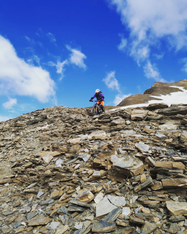
The first roughly 100 meters of descent are finally rideable and immediately offer a beautiful, technical descent. The difficulty is roughly full S4, with some S4+ sections, on alpine and rocky terrain. After the ridge section, it’s almost a relief to get back in the saddle, even though the ride immediately demands concentration and good technique. Shortly after, you’ll encounter a brief section where you’ll need to walk your bike. It’s not particularly difficult compared to the one you just tackled on the climb, but it momentarily interrupts the flow of the descent.
Toward Lake Aviasco
In this version, you’ll descend toward the lake area. The descent passes through the Lake Varrozza area and continues toward Lake Aviasco. This section is probably the least successful part of the ride from a purely cycling standpoint: the terrain is very loose, and in some places it becomes difficult to keep the bike on track. It is not necessarily the most technically challenging section of the route, but the unstable surface makes riding less enjoyable than in the other sections. Once you reach Lake Aviasco, you must then begin climbing again to reach the Aviasco Pass.
High-Altitude Alternative: Monte dei Frati
There is a decidedly more interesting alternative for those who want to maintain the alpine character of the ride. Instead of descending toward Lake Aviasco, you can stay on the ridge, pass beneath Monte Varrozza, and continue toward Monte dei Frati. The ridge route offers stunning views and, after the challenges encountered at Cabianca, presents no particular difficulties all the way to the Monte dei Frati area. Just before the descent, however, there is a 1- to 2-meter drop where you’ll need to carry your bike down. It’s advisable to have at least two people so you can help each other. From Monte dei Frati, a completely different descent begins: about 150 meters of elevation loss, roughly from 2,450 to 2,300 meters, which is very steep and technical, with a difficulty rating of S5. It’s a more challenging route, but also much more interesting in terms of both the ride and the scenery.
Aviasco Pass – Lake Colombo
Once you reach the Aviasco Pass area, one of the most beautiful and enjoyable sections of the route begins. You descend along a lovely alpine trail toward Lake Colombo, gradually entering the Laghi Gemelli area. From Lake Colombo, you continue descending toward Lake Pian delle Casere. This section is significantly easier to ride than the previous ones, with difficulty generally around S2/S3, though it still includes some technical passages. After the challenging terrain of Cabianca and Aviasco, this section finally allows for more continuous riding.
Return to Carona – CAI 211
From Pian delle Casere, this route takes the most direct path back to Carona, using the CAI 211 trail. And this is where the ride gets tough again. The 211 is an extremely physically demanding, technical, and continuous descent. It doesn’t just have a few isolated difficult sections—it’s relentless practically from start to finish. The overall difficulty is in the S4 range, with numerous sections reaching S5. The terrain is predominantly rocky and requires constant effort from both arms and legs. After everything you’ve already tackled in the upper section, fatigue becomes a major factor in managing the descent. It is therefore a finish suited for those who truly want to complete the loop while maintaining a high technical level right to the very end. For those who, having reached this point, prefer a less extreme conclusion, it is possible to consider an alternative descent, such as the Sirena, described in another route published on the website.
In summary
This is an extreme variation of the classic Laghi Gemelli loop. The first section from Carona involves gaining about 1,000 meters in elevation—mostly rideable—but from the Fregabolgia area onward, the terrain changes radically. A long portage toward Cabianca begins, with the final 400 meters being particularly challenging over rocky and loose terrain. The crucial point, however, is the extremely exposed ridge below Cabianca. The most difficult section is only a few meters long, but it requires great confidence on alpine terrain and the ability to handle both the exposure and the mountain bike simultaneously. This is not a ride for those afraid of heights, and it is not a place to improvise. Once past Cabianca, a long sequence of technical descents, climbs, and traverses begins, leading to the Aviasco Pass. From Lake Colombo, the terrain offers a smoother stretch before the grueling final section on the CAI 211 trail, featuring S4 difficulty and numerous S5 sections all the way to Carona. For those who want to further increase the challenge and difficulty of the upper section, the ridge variant via Monte dei Frati is probably the most interesting option, but it adds a very steep S5 descent section.
Technical Details
- Trail Style: All Mountain / Extreme / Alpine Adventure
- MTB: Only for very experienced riders
- E-MTB: Strongly discouraged
- Rideable ascent: approximately 1,000 m elevation gain in the first section
- Portage: Very extensive from the Fregabolgia area to Cabianca and during the ascent to Passo di Aviasco
- Ascent difficulty: Extreme due to portage and exposure
- Descent difficulty: S4/S5
- Exposure: Very high along the Cabianca ridge section
- Terrain: Rocky, loose, and alpine; highly recommended to be dry
- Final section: CAI 211 ? S4 with numerous S5 sections
WARNING: The ridge section below Cabianca represents the route’s main difficulty. It is a very exposed stretch, lacking safety equipment, and must be tackled on a mountain bike. If you are not completely confident in your ability to navigate this type of terrain, you must turn back.