Italiano
 Deutsch
Lago di Pietra Quadra

Mountain Biking Route: Monte Pietra Quadra – Tre Pizzi – Roccolo del VerroppioA spectacular mountain biking variant to add to the Complete Roncobello Tour or the Roccolo Verroppio route ? The Roccoli Trail—Pietra Quadra area.
From the Roccoli area, you leave the classic route and climb toward Lake Pietra Quadra, expecting about 250 m of elevation gain while pushing or carrying your bike.
This variant is therefore not designed to make the ride more bike-friendly: you climb here for the scenery, the views, and above all for the beautiful technical section that follows.
If you reach Pietra Quadra early enough, the sun streaming in from the Madonnino illuminates the lake, creating one of the most beautiful scenes in the area.
Monte Pietra Quadra
Once you reach the lake area, the variant continues by climbing to the summit of Monte Pietra Quadra.
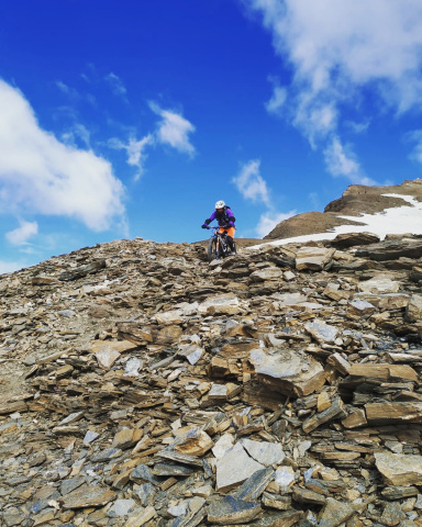
This section also requires you to carry your bike, but it adds a true summit to the ride and, above all, a beautiful technical descent.
From the summit, the first 50 meters or so are the most difficult and may require you to dismount, depending on your skill level.
Once past this initial section, however, a long and beautiful descent begins that remains at a solid S4 level.
This isn’t just a few isolated S4 sections: the technical difficulty remains high and fairly consistent across alpine terrain, and this is precisely one of the route’s highlights.
Riders who handle S4 well will find this a very fun and satisfying descent. Those who tackle S4 only occasionally, however, should expect to walk several sections.
Tre Pizzi ? Roccolo del Verroppio
Once the descent from Monte Pietra Quadra is complete, continue toward the bivouac and then around the Tre Pizzi.
Here, too, the trail remains technical, with numerous interesting sections.
The difficulty continues mainlyat S4, with a few short sections that can reach S5. The most difficult spots are localized and can be bypassed on foot.
There are also a couple of short, slightly exposed sections, though there are no long stretches where exposure is the main challenge.
Finally, you reach Roccolo del Verroppio, where you rejoin the corresponding descent and the Sentiero dei Roccoli.


Difficulty: What to Really Expect
This is a true mountain biking variant, intended for those willing to carry their bike to earn a technical descent in an alpine setting.
The climb involves about 250 m of elevation gain carried on your shoulders.
From the summit of Monte Pietra Quadra, the first 50 meters are the most difficult section; afterward, the descent remains at a solid S4 level and is fairly continuous.
The subsequent route around the Tre Pizzi also maintains a high level of difficulty, with some localized S5 sections.
This variant is therefore not recommended for those simply seeking a scenic alternative to the classic route: it makes sense primarily for those who love mountain biking and have a good command of S4 terrain.
Style: AM / Mountain Biking
Duration of the variant: approximately 2 hours
MTB: Yes
E-MTB: Not recommended
Pushing/carrying: about 250 m elevation gain, mostly pushing the bike on your shoulder
Monte Pietra Quadra: the first 50 m are very challenging, followed by plenty of continuous S4
Tre Pizzi – Verroppio: mostly S4 with a few short S5 sections
Maximum difficulty: Localized S5
Exposure: a couple of short sections; not the main challenge
Drainage: Good
Water sources: None
Views: 9/10
Downhill sections: 8/10
Ride difficulty: Medium-high