HOME RANKINGS CHALLENGES ROUTES NEAR ME PLANNING SEARCH LOGIN
Italy - Piemonte, TO
2026/07/01 15:35:02

Fondo - Palit - Fondo - Valchiusella

3 Downloads
0
 
Share

Key Takeaways / Scheda Tecnica

Disciplina:
Mountain Bike (MTB)
Percorso:
Fondo - Palit - Fondo - Valchiusella
Place:
Italy - Piemonte, TO
Km:
11,55 km
Vertical meters:
+630 mt (Quota Min: 996m - Max: 1619m)
Route difficulty:
1/5
Landscapes:
3/5
Formato Traccia:
GPX Download disponibile
Author
gmzolenart
(137)
Place
Italy - Piemonte, TO
Km
11,55 km
Elapsed time
02:11:25
Vertical meters
+630 mt (996 - 1619)
Route difficulty
Landscapes
Last update
2026/07/01 21:06:00
Comments
0
Description

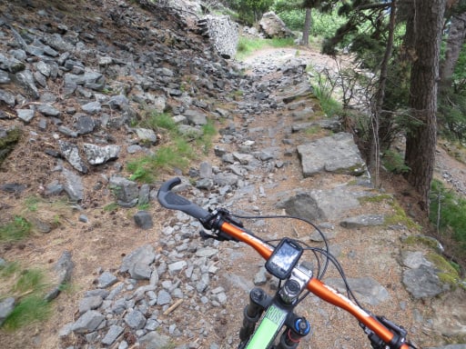
The route starts at the entrance to Fondo in Valchiusella at an elevation of 1,074 meters, following 2 km of paved road through the hamlets of Durando and Vaudanza, which serves as the starting point for ski mountaineering in the winter. The dirt road that follows is wide, with a mix of grassy and rocky terrain, and remains rideable throughout, though it is very steep in places with a few concrete hairpin turns. After 4 km, you reach the Palit ski lifts at an elevation of 1,700 meters, which began operating in 1963 and closed permanently in 2006. Nothing of particular note: cows fenced in at the Bec area with no herders; on the descent, I passed a tired e-biker who was heading uphill. Returned via the same route used for the ascent.

Final stretch of the ascent

Foto itinerario MTB Fondo - Palit - Fondo - Valchiusella - Italy - Piemonte, TO

Arrival

Foto itinerario MTB Fondo - Palit - Fondo - Valchiusella - Italy - Piemonte, TO

Punta Palit, between the left post and the pylon

Foto itinerario MTB Fondo - Palit - Fondo - Valchiusella - Italy - Piemonte, TO


Foto itinerario MTB Fondo - Palit - Fondo - Valchiusella - Italy - Piemonte, TO

Valchiusella from Fondo to Tallorno

Foto itinerario MTB Fondo - Palit - Fondo - Valchiusella - Italy - Piemonte, TO

Start: large parking lot

Foto itinerario MTB Fondo - Palit - Fondo - Valchiusella - Italy - Piemonte, TO

Download our free mobile app to send this route to your Garmin device or to navigate it on OSM maps. Android - iOS
Local weather
Lun 00:00
3 °C
Lun 12:00
6 °C
Mar 00:00
5 °C
Mar 12:00
7 °C
Mer 00:00
7 °C
Mer 12:00
9 °C
Gio 00:00
7 °C
Gio 12:00
8 °C
Ven 00:00
8 °C
Ven 12:00
13 °C

Graph

Nearest Routes

2026/09/06
- Italy - Piemonte, TO
gmzolenart
(137)
10,97 km
Km
+500 mt
Vertical meters
Route difficulty
Landscapes
2026/06/20
- Italy - Piemonte, TO
gmzolenart
(137)
7,36 km
Km
+500 mt
Vertical meters
Route difficulty
Landscapes
2022/08/22
- Italy - Valle d'Aosta, AO
nonnocarb
(324)
24,52 km
Km
+466 mt
Vertical meters
Route difficulty
Landscapes
2022/09/18
- Italy - Valle d'Aosta, AO
gmzolenart
(137)
18,95 km
Km
+1 050 mt
Vertical meters
Route difficulty
Landscapes
2022/08/06
- Italy - Valle d'Aosta, AO
gmzolenart
(137)
29,26 km
Km
+1 467 mt
Vertical meters
Route difficulty
Landscapes
2022/08/22
- Italy - Valle d'Aosta, AO
nonnocarb
(324)
30,60 km
Km
+1 265 mt
Vertical meters
Route difficulty
Landscapes
2026/09/13
- Italy - Piemonte, TO
gmzolenart
(137)
20,94 km
Km
+850 mt
Vertical meters
Route difficulty
Landscapes
2022/11/18
- Italy - Piemonte, TO
gmzolenart
(137)
21,96 km
Km
+735 mt
Vertical meters
Route difficulty
Landscapes
30,47 km
Km
+1 080 mt
Vertical meters
Route difficulty
Landscapes
2022/11/20
- Italy - Piemonte, TO
gmzolenart
(137)
29,49 km
Km
+1 172 mt
Vertical meters
Route difficulty
Landscapes

0 Comments