Italiano
 Deutsch
Marina di Campo, Capo Stella
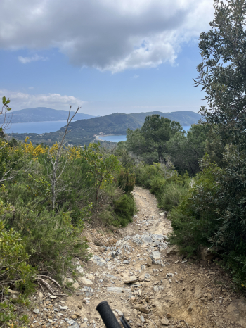
The route starts in Marina di Campo and climbs toward Monte Tambone along a steep but always rideable dirt road. Once you reach the ridge, a short climb takes you over the pass to Monte Fonza, where a beautiful trail begins (follow the recently maintained switchback trail set up by local cyclists) on firm soil and rock with a few loose sections. Follow the signs for Lacona and proceed along a scenic single track with a few steep sections and technical passages, flowing stretches, traverses, and a few short climbs (the uphill section has been improved and is now rideable). Once you reach a wide forest road, climb for a short stretch until you come to a trail on the right that descends to Lacona. The first section is smooth, then becomes a beautiful trail with technical sections over rock and steps, followed by a more flowing final stretch.
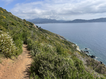
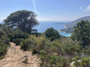
Turn right and pass through Lacona; before reaching Capo Stella, turn right toward the campground, go around the campground, and take the beautiful trail that circles Capo Stella. The first section is a narrow single track, smooth but with some exposure and a few ups and downs, offering a breathtaking view from the top of the cliff. The final section is on a wide forest road that climbs up to the tip of Capo Stella. Here, it continues on a decidedly more technical single track that rejoins a forest road. You climb up to take the ridge trail; a single track that climbs gradually and then descends toward Lacona, with only the final section being more technical on loose rock.
In Lacona, you climb on asphalt to Colle Reciso, where you take the GTE, a wide forest road with a gentle climb and a slight incline. You’ll come to the junction with the trail to Monte Barbatoia, a moderate climb up to a plateau, and on the left begins the legendary Serra del Pero. A classic trail in the area; smooth at the start and then gradually more technical sections over rock and steps, but with firm footing here as well, offering a beautiful view of the Gulf of Lacona.
On the asphalt, keep left and take the small roads up the beautiful climb through the olive groves (a steep but well-rideable trail) that brings you back to the GTE you took earlier. Follow it, leaving Monte Barbatoia behind to take the Guendalone trail. This is also a beautiful technical descent, alternating flow sections with trial-style passages over rock, followed by loose stones and rocky sections. You arrive near Colle di Procchio and keep left to take the climb on a forest road (recently improved) that leads to S. Ilario. From here, take the paved road to S. Piero and then, via forest roads, take the single track that descends to Colle Palomba.
The first section is technical but smooth; at a forest road, keep left (going right would take you toward Cavoli and onto the SP, an easy alternative). A very technical trail begins with tight switchbacks and challenging loose rocks, leading directly to Colle Palomba. Here, take the scenic (but somewhat exposed) trail leading toward Capo Poro. Tackle a very tough uphill dirt road, followed by the descent toward Capo Poro. Turn right onto the single track (with a short push to get going) and then follow a smooth trail to Marina di Campo and from there to the parking lot.
Medium difficulty S3, but some sections are S4/S5 #elba