HOME RANKINGS CHALLENGES ROUTES NEAR ME PLANNING SEARCH LOGIN
Italy - Trentino-Alto Adige/Südtirol, TN
2025/10/16 21:23:50

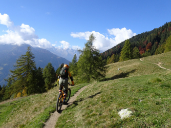
Valagola e i trail della Val Rendena

32 Downloads
1
 
Share
Author
miciolo
(53)
Place
Italy - Trentino-Alto Adige/Südtirol, TN
Km
32,28 km
Elapsed time
170:51:08
Vertical meters
+1 366 mt (793 - 1865)
Route difficulty
Landscapes
Last update
2025/10/17 08:18:37
Comments
0
Description

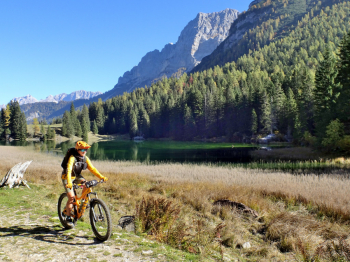
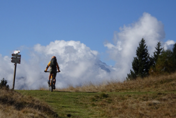
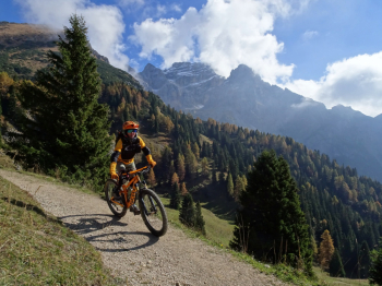
Start of this hike is from the capacious parking lot in front of Pinzolo ski lifts. Climb up to Sant'Antonio di Mavignola on a paved road closed to traffic. Follow the trail to the nice dirt road that gently takes us to the Malga and Lake Valagola. Past the lake the slopes become steeper and it is necessary to push the bike for about 250 meters of elevation gain. We arrive at the Cappelletta del Passo Bregn de l'ors where the Brenta Group presents itself in all its splendor. With up and down we arrive at the Gotro Pass where we descend in the direction of Malga Movlina.

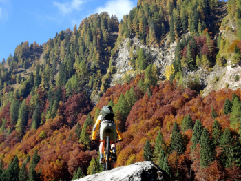
Before arriving at the Malga we must take the beautiful trail that descends to the right into the meadows and arrives at Malga Bandalors. From the malga starts a trail that is initially easy to pedal but then has several short pushing sections until Pra Rodont. From Pra Rodont on easy forestry short stretch until entering the Circinà trail. Another very short stretch of forestry and then down the Cavradoss trail. At the bottom we cross to the other side of the stream on a wooden bridge and face short uphill ramps to return to Sant'Antonio. From Sant'Antonio to Pinzolo follow the technical trail that cuts the paved road made on the way out. Trail with S2 difficulty with short S3 sections.

We started from Sant'Antonio di Mavignola where, however, parking is scarce. More photos and information can be found in the photoreport.

Download our free mobile app to send this route to your Garmin device or to navigate it on OSM maps. Android - iOS
Local weather
Thu 00:00
10 °C
Thu 12:00
19 °C
Fri 00:00
14 °C
Fri 12:00
15 °C
Sat 00:00
13 °C
Sat 12:00
17 °C
Sun 00:00
13 °C
Sun 12:00
18 °C
Mon 00:00
14 °C
Mon 12:00
18 °C

Graph

Nearest Routes

2025/10/15
- Italy - Trentino-Alto Adige/Südtirol, TN
miciolo
(53)
41,13 km
Km
+1 870 mt
Vertical meters
Route difficulty
Landscapes
2024/10/08
- Italy - Trentino-Alto Adige/Südtirol, TN
miciolo
(53)
36,80 km
Km
+1 573 mt
Vertical meters
Route difficulty
Landscapes
2023/04/14
- Italy - Trentino-Alto Adige/Südtirol, TN
miciolo
(53)
25,49 km
Km
+1 229 mt
Vertical meters
Route difficulty
Landscapes
2025/08/25
- Italy - Trentino-Alto Adige/Südtirol, TN
sottalfix
(1)
24,02 km
Km
+1 000 mt
Vertical meters
Route difficulty
Landscapes
2024/11/26
- Italy - Trentino-Alto Adige/Südtirol, TN
biciclitu
(30)
26,31 km
Km
+1 500 mt
Vertical meters
Route difficulty
Landscapes
2025/10/23
- Italy - Trentino-Alto Adige/Südtirol, TN
biciclitu
(30)
16,44 km
Km
+1 000 mt
Vertical meters
Route difficulty
Landscapes
2026/01/21
- Italy - Trentino-Alto Adige/Südtirol, TN
biciclitu
(30)
29,13 km
Km
+1 500 mt
Vertical meters
Route difficulty
Landscapes
2024/09/11
- Italy - Trentino-Alto Adige/Südtirol, TN
biciclitu
(30)
19,01 km
Km
+1 300 mt
Vertical meters
Route difficulty
Landscapes
2023/08/22
- Italy - Trentino-Alto Adige/Südtirol, TN
richin
(5)
35,77 km
Km
+2 400 mt
Vertical meters
Route difficulty
Landscapes
2023/10/19
- Italy - Trentino-Alto Adige/Südtirol, TN
biciclitu
(30)
18,82 km
Km
+1 200 mt
Vertical meters
Route difficulty
Landscapes

0 Comments