HOME RANKINGS CHALLENGES ROUTES NEAR ME PLANNING SEARCH LOGIN
Italy - Trentino-Alto Adige/Südtirol, TN
2025/10/23 13:58:25

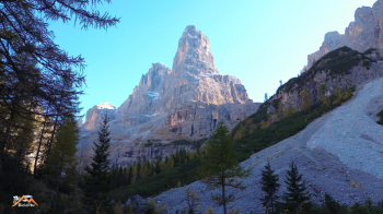
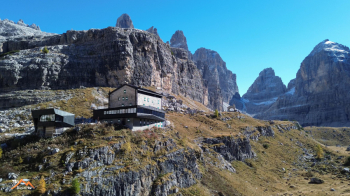
Rifugio Brentei, val di Brenta

2 Downloads
0
 
Share
Author
biciclitu
(30)
Place
Italy - Trentino-Alto Adige/Südtirol, TN
Km
16,44 km
Elapsed time
07:27:58
Vertical meters
+1 000 mt (1168 - 2190)
Route difficulty
Landscapes
Last update
2025/10/23 16:16:37
Comments
0
Description

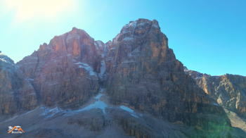
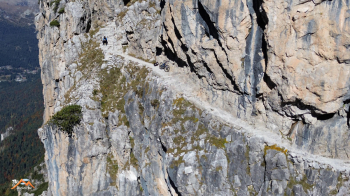
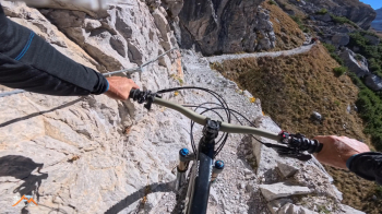
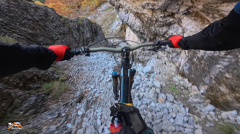
This beautiful mountaineering cycle starts from the Val Brenta parking lot shortly after the Pra della Casa agriturismo in San Antonio di Mavignola. We backtrack for a few hundred meters to Pra della Casa and a beautiful forest road takes us to Vallesinella Bassa passing by the Cascate di Mezzo Refuge, not completely rideable due to steep inclines at times. From Vallesinella we take trail 317for Rif. Casinei, all with bikes on our backs. Up again on the beautiful and very scenic 318 to Rifugio Brentei with bike on shoulder in the first sector then pedalable, pushable sections and exposed segments downhill. We are on the vast grassy clearing that divides Val Brenta with Val Brenta Alta and is home to the iconic Rifugio Brentei in an extraordinarily beautiful setting.

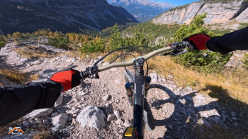
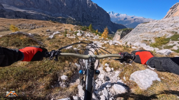
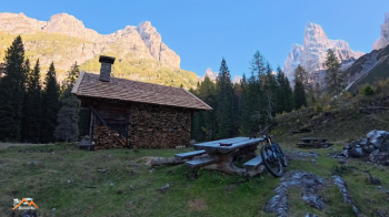
Just before the Rif. the descent route kicks off: trail 323 that descends the legendary Val Brenta. The trail is immediately challenging and not all doable by bike, there are also 2 passages equipped with stirrups but nothing complicated. After the first stony segment we are on the plateau that hosts the beautiful Malga Brenta Alta (now a cozy bivouac) with exciting views of the Dolomites. We continue on the 323 that plunges down into the valley on a steep trail, the first few meters not cyclable but then tight switchbacks with a fine gravel bottom that is very conducive to biking downhill, you ride it all the way. Then forest and more rocky rocky parts but still in the saddle with much, much fun all the way back to the parking lot where we started.

Download our free mobile app to send this route to your Garmin device or to navigate it on OSM maps. Android - iOS
Local weather
Thu 00:00
7 °C
Thu 12:00
16 °C
Fri 00:00
11 °C
Fri 12:00
13 °C
Sat 00:00
10 °C
Sat 12:00
14 °C
Sun 00:00
10 °C
Sun 12:00
15 °C
Mon 00:00
12 °C
Mon 12:00
16 °C

Graph

Nearest Routes

2024/11/26
- Italy - Trentino-Alto Adige/Südtirol, TN
biciclitu
(30)
26,31 km
Km
+1 500 mt
Vertical meters
Route difficulty
Landscapes
2026/01/21
- Italy - Trentino-Alto Adige/Südtirol, TN
biciclitu
(30)
29,13 km
Km
+1 500 mt
Vertical meters
Route difficulty
Landscapes
2024/09/11
- Italy - Trentino-Alto Adige/Südtirol, TN
biciclitu
(30)
19,01 km
Km
+1 300 mt
Vertical meters
Route difficulty
Landscapes
2023/08/22
- Italy - Trentino-Alto Adige/Südtirol, TN
richin
(5)
35,77 km
Km
+2 400 mt
Vertical meters
Route difficulty
Landscapes
2023/10/19
- Italy - Trentino-Alto Adige/Südtirol, TN
biciclitu
(30)
18,82 km
Km
+1 200 mt
Vertical meters
Route difficulty
Landscapes
2024/09/14
- Italy - Trentino-Alto Adige/Südtirol, TN
Staff
(108)
12,00 km
Km
+11 mt
Vertical meters
Route difficulty
Landscapes
2024/09/14
- Italy - Trentino-Alto Adige/Südtirol, TN
Staff
(108)
29,33 km
Km
+617 mt
Vertical meters
Route difficulty
Landscapes
2024/09/14
- Italy - Trentino-Alto Adige/Südtirol, TN
Staff
(108)
11,72 km
Km
+11 mt
Vertical meters
Route difficulty
Landscapes
2023/04/14
- Italy - Trentino-Alto Adige/Südtirol, TN
miciolo
(53)
25,49 km
Km
+1 229 mt
Vertical meters
Route difficulty
Landscapes
2025/10/16
- Italy - Trentino-Alto Adige/Südtirol, TN
miciolo
(53)
32,28 km
Km
+1 366 mt
Vertical meters
Route difficulty
Landscapes

0 Comments