HOME RANKINGS CHALLENGES ROUTES NEAR ME PLANNING SEARCH LOGIN
Italy - Trentino-Alto Adige/Südtirol, TN
2026/01/21 11:29:32

Malga Flavona

41 Downloads
0
 
Share
Author
biciclitu
(30)
Place
Italy - Trentino-Alto Adige/Südtirol, TN
Km
29,13 km
Elapsed time
08:29:08
Vertical meters
+1 500 mt (1500 - 2433)
Route difficulty
Landscapes
Last update
2026/01/21 12:06:41
Comments
0
Description

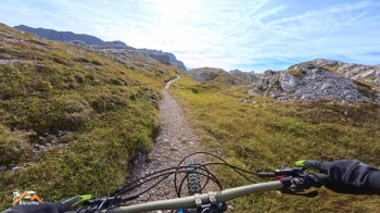
This peaceful but nonetheless challenging hike starts from the car park in Vallesinella. We will visit Campo and Malga Flavona, the vertical walls of the Campa subgroup and the iconic Turion Basso. We return to Madonna di Campiglio and, after a couple of grueling climbs to the Grosée cable car, we continue along the forest road that serves the lifts to the Stoppani refuge and the Grostè pass, with no room for error.

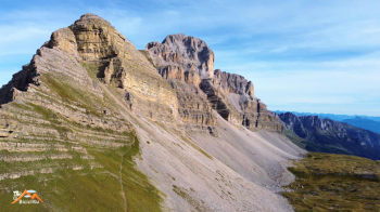
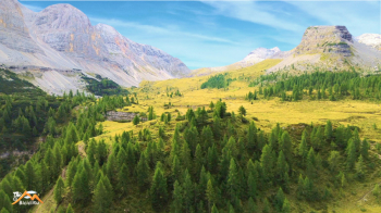
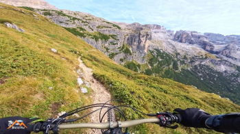
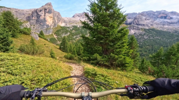
We descend (with short stretches of biking alongside) the 301 and at the junction with the 314, we go down to the left and then right on the 317, having lots of fun until we reach the beautiful Campo Flavona, the iconic Turion Basso, and in front of us, the vertical walls of the imposing Campa subgroup, and then down again to the beautiful Malga Flavona. Excellent also in terms of refreshments. I didn't reach my original destination, but continued on the 330 towards Bocchetta di Val Scura. However, due to a technical problem, I had to give up a short distance away.

I changed the trip to Malga Flavona and the resulting route.

which, in my opinion, was still physically challenging and exciting from a cycling point of view.

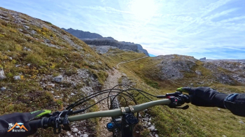
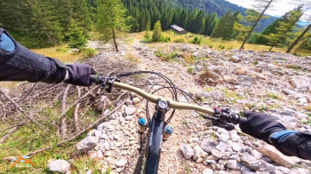
Now, from Malga Flavona, we struggle back up the path we just descended to the Grostè pass, about 600m D+ divided as follows: 60% pushing, 20% carrying, and 20% cycling.

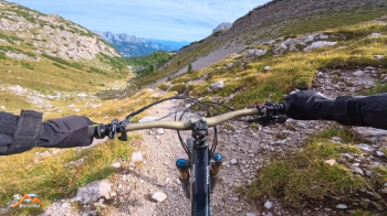
From the pass, we descend to the Graffer refuge below, then down the enjoyable Corna Rossa trail to Vallesinella, where we parked the car, not with much but with a lot of fun.


Download our free mobile app to send this route to your Garmin device or to navigate it on OSM maps. Android - iOS
Local weather
Thu 00:00
7 °C
Thu 12:00
14 °C
Fri 00:00
10 °C
Fri 12:00
11 °C
Sat 00:00
9 °C
Sat 12:00
12 °C
Sun 00:00
8 °C
Sun 12:00
14 °C
Mon 00:00
10 °C
Mon 12:00
14 °C

Graph

Nearest Routes

2025/10/23
- Italy - Trentino-Alto Adige/Südtirol, TN
biciclitu
(30)
16,44 km
Km
+1 000 mt
Vertical meters
Route difficulty
Landscapes
2024/11/26
- Italy - Trentino-Alto Adige/Südtirol, TN
biciclitu
(30)
26,31 km
Km
+1 500 mt
Vertical meters
Route difficulty
Landscapes
2023/10/19
- Italy - Trentino-Alto Adige/Südtirol, TN
biciclitu
(30)
18,82 km
Km
+1 200 mt
Vertical meters
Route difficulty
Landscapes
2023/08/22
- Italy - Trentino-Alto Adige/Südtirol, TN
richin
(5)
35,77 km
Km
+2 400 mt
Vertical meters
Route difficulty
Landscapes
2024/09/11
- Italy - Trentino-Alto Adige/Südtirol, TN
biciclitu
(30)
19,01 km
Km
+1 300 mt
Vertical meters
Route difficulty
Landscapes
2024/09/14
- Italy - Trentino-Alto Adige/Südtirol, TN
Staff
(108)
29,33 km
Km
+617 mt
Vertical meters
Route difficulty
Landscapes
2024/09/14
- Italy - Trentino-Alto Adige/Südtirol, TN
Staff
(108)
12,00 km
Km
+11 mt
Vertical meters
Route difficulty
Landscapes
2024/09/14
- Italy - Trentino-Alto Adige/Südtirol, TN
Staff
(108)
11,72 km
Km
+11 mt
Vertical meters
Route difficulty
Landscapes
2024/09/14
- Italy - Trentino-Alto Adige/Südtirol, TN
Staff
(108)
18,55 km
Km
+562 mt
Vertical meters
Route difficulty
Landscapes
2024/09/14
- Italy - Trentino-Alto Adige/Südtirol, TN
Staff
(108)
22,04 km
Km
+1 064 mt
Vertical meters
Route difficulty
Landscapes

0 Comments