
 Italiano
 Deutsch
2023/08/22 21:37:18
Corna Rosa Trail
Author
Place
Italy - Trentino-Alto Adige/Südtirol, TN
Km
35,77 km
Elapsed time
05:45:14
Vertical meters
+2 400 mt (852 - 2435)
Route difficulty
Landscapes
Last update
2023/08/28 14:09:31
Comments
Hotels
Description
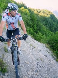
Si prende la funivia per il Grostè, poi si scende un tratto di freeride fino al rifugio Graffer, da qui comincia il lunghissimo e bellissimo trail della Corna Rosa, a tratti esposto con parti tecniche ed altre più scorrevoli fino alle cascate di Vallesinella Media ( rifugio ). Poi giù per il trail dell'Arciduca ed ancora giù per il San Vili, tagliando i tornanti fino alla funivia di Tulot che ci porta a Malga Cioca e da qua giù prima per il trail Circinà e poi per il trail Cavrados. Arrivati ancora alla forestale si prenderà a destra per Madonna di Campiglio in dolce ascesa per terminare questo bellissimo tour. Dislivello Pedalato 700 metri circa , il resto è funivia.
Local weather
Thu 00:00

12 °C
Thu 12:00

21 °C
Fri 00:00

14 °C
Fri 12:00

19 °C
Sat 00:00
13 °C
Sat 12:00
20 °C

Graph
Nearest Routes
18,82 km
Km
+1 200 mt
Vertical meters
Route difficulty
Landscapes
19,01 km
Km
+1 300 mt
Vertical meters
Route difficulty
Landscapes
16,44 km
Km
+1 000 mt
Vertical meters
Route difficulty
Landscapes
29,13 km
Km
+1 500 mt
Vertical meters
Route difficulty
Landscapes
29,33 km
Km
+617 mt
Vertical meters
Route difficulty
Landscapes
11,72 km
Km
+11 mt
Vertical meters
Route difficulty
Landscapes
26,31 km
Km
+1 500 mt
Vertical meters
Route difficulty
Landscapes
2024/09/14
- Italy - Trentino-Alto Adige/Südtirol, TN 22,04 km
Km
+1 064 mt
Vertical meters
Route difficulty
Landscapes