HOME RANKINGS CHALLENGES ROUTES NEAR ME PLANNING SEARCH LOGIN
Italy - Trentino-Alto Adige/Südtirol, TN
2025/06/26 10:19:56

Ude's Trail - Completo - Dolomiti Paganella Bike

10 Downloads
1
 
Share

Key Takeaways / Scheda Tecnica

Disciplina:
Mountain Bike (MTB)
Percorso:
Ude's Trail - Completo - Dolomiti Paganella Bike
Località:
Italy - Trentino-Alto Adige/Südtirol, TN
Distanza:
11,62 km
Dislivello Positivo:
+229 mt (Quota Min: 1009m - Max: 1497m)
Difficoltà Tecnica:
4/5
Valutazione Panorami:
4/5
Formato Traccia:
GPX Download disponibile
Author
steve-U
(29)
Place
Italy - Trentino-Alto Adige/Südtirol, TN
Km
11,62 km
Elapsed time
01:18:58
Vertical meters
+229 mt (1009 - 1497)
Route difficulty
Landscapes
Last update
2025/06/26 13:30:46
Comments
0
Description

Ude's Trail Dolomiti Paganella Bike (Molveno - Andalo)
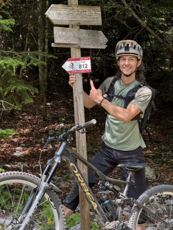
Foto itinerario MTB Ude's Trail - Completo - Dolomiti Paganella Bike - Italy - Trentino-Alto Adige/Südtirol, TN

Official data:

Length : about 8.8km

Height difference: +290m / -750m

Difficulty: intermediate/advanced

Departure: locality Tovre (altitude 1,513 meters) reachable by Molveno-Pradel gondola and Pradel-Montanara chairlift.

Finish: Andalo - locality Priori

First segment (from Loc. Tovre to Pian dei Sarnacli): until June 21 on this first segment the transit of MTBs is forbidden, by indication of the PNAB (Adamello Brenta National Park) as in this area there are important singing arenas and breeding areas of the capercaillie.

Second segment (from Sarnacli to Priori): can be tackled in all seasons as it is neither subject to the restrictions of the first. It is not served by lifts so it can only be reached by pedaling.

Along the route you will find 2 drinking fountains: one at the start of the first segment (Loc. Fontanella) and the second at Pian dei Sarnacli.

Download our free mobile app to send this route to your Garmin device or to navigate it on OSM maps. Android - iOS
Local weather
Tue 00:00
6 °C
Tue 12:00
9 °C
Wed 00:00
8 °C
Wed 12:00
10 °C
Thu 00:00
8 °C
Thu 12:00
7 °C
Fri 00:00
3 °C
Fri 12:00
5 °C
Sat 00:00
4 °C
Sat 12:00
3 °C

Graph

Nearest Routes

2022/09/22
- Italy - Trentino-Alto Adige/Südtirol, TR
78,77 km
Km
+6 258 mt
Vertical meters
Route difficulty
Landscapes
2024/12/18
- Italy - Trentino-Alto Adige/Südtirol, TN
biciclitu
(34)
12,39 km
Km
+1 350 mt
Vertical meters
Route difficulty
Landscapes
2026/08/25
- Italy - Trentino-Alto Adige/Südtirol, TN
miciolo
(55)
37,35 km
Km
+1 640 mt
Vertical meters
Route difficulty
Landscapes
2025/09/13
- Italy - Trentino-Alto Adige/Südtirol, TN
steve-U
(29)
71,77 km
Km
+640 mt
Vertical meters
Route difficulty
Landscapes
2025/09/30
- Italy - Trentino-Alto Adige/Südtirol, TN
biciclitu
(34)
21,01 km
Km
+1 600 mt
Vertical meters
Route difficulty
Landscapes
2024/07/07
- Italy - Trentino-Alto Adige/Südtirol, TN
marco
(195)
39,40 km
Km
+189 mt
Vertical meters
Route difficulty
Landscapes
2026/05/03
- Italy - Trentino-Alto Adige/Südtirol, TN
marco
(195)
27,11 km
Km
+1 447 mt
Vertical meters
Route difficulty
Landscapes
2023/01/07
- Italy - Trentino-Alto Adige/Südtirol, TN
gaspa91
(4)
32,43 km
Km
+1 350 mt
Vertical meters
Route difficulty
Landscapes
2026/01/21
- Italy - Trentino-Alto Adige/Südtirol, TN
biciclitu
(34)
29,13 km
Km
+1 500 mt
Vertical meters
Route difficulty
Landscapes
2025/10/23
- Italy - Trentino-Alto Adige/Südtirol, TN
biciclitu
(34)
16,44 km
Km
+1 000 mt
Vertical meters
Route difficulty
Landscapes

0 Comments