Italiano
 Deutsch
Disagio in Paradiso: Gran Collet 2832 m - Vittorio Emanuele 2700 m - Chabod 2700 m

Cycloalpine itinerary with very difficult trialist descents only for enthusiasts of the genre.
We celebrate the 100th anniversary of PNGP with a heavenly itinerary among blinding views, technical descents and Discomfort in abundance. Welcome to VdA, welcome to PNGP.
Start from Pravieux 1820 m Valsavarenche. Large parking lot with hidden water after small bridge opposite side of stream. Pedal sloppy to Pont and then on the unfinished waste of the road to the Nivolet to 2200 m. Taste of day's push-port up to Upper Meyes 2450 m. Back in the saddle now on fantastic grasslands and traverse (only short landslide to overcome) worth the day. Perfect trail and spatial views, already known here Basei but in reverse. We could continue trulli trulli to the Nivolet plain but galeotta was the stake and just before Pian Borgnoz we scrabble down the 3A appetizer of the technical delirium that will await us in the early afternoon. It is then only 300 m but very challenging and slow (especially once we cross the slope). You can get an idea with this video from our friend Pascal 3A calculating that PJ is a mtb alien. Beware of crossing the Dora because the bridge has collapsed and you have to make do. Good start :-)
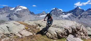
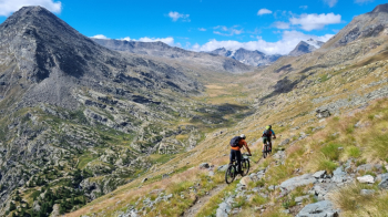
Back on the main trail we get back in the saddle almost indefinitely first slightly uphill then flat in the impressive steppe of the Nivolet. Beddissimo ! 3 km on pedal can be enough. Taka zü. Another 400 m of pushing on beautiful path but also of resounding pedaling on plateau brings us to Gran Collet 2832 m. Himalayan apotheosis. An indescribable balcony over what remains of the glaciers of the entire Gran Paradiso only slightly marred by a few too many noisy hikers.
Descent ON: but where do you descend from ? and where do you go ? but are you sure ? Yes, zö de lè !
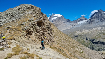
On the first wall we make a splash by brushing the hairpin bends on scree but just below there is little to shine. 800 m of lactic acid almost always at the human limit and at various points even beyond. Insignificant speed, endless obstacles, carved hairpins ... not 1 m easy. A gym of descending discomfort among the best worst in the VdA. It never lets up even going down in altitude indeed in places even the vegetation raises the level further partially hiding the "path". We land among the merenderos of the Tetras Lyre refuge brazed and incredulous to be still alive. Marooo !
Fortunately we climb back up and rest for another 700 m all against the mountaineers / merenderos / ciaparatt descending from Vittorio Emanuele. At the sight of the bikes the looks and questions range from incredulous to disgusted but you knew, it is perhaps the most frequented trail in VdA. Out of modesty we stop a few meters before the Refuge barrel and are ready to traverse to the Chabot. Optimistic palina marks 1.45 h but Kilian will have written it because we even taking into account the photographic dickering and a 360 without consequences will take longer. It is in fact a traverse with lots of ups and downs and rocks so time and discomfort is needed. Cyclability 50% optimistic as the post :-) but with nice little descents and space environment. Zero humanoids. We arrive for dinner at the Chabod but instead of minestrone we have additional climb behind the Refuge to go on the service descent to Montandaynè (it seemed bad to do the main trail). Good choice ! Pristine valley at Golden Hour with excellent trail first slightly sketchy then luxury to the huge abandoned alpine pasture. Not even time to say "luck that it is not difficult given the degree of abrasion" that from 2400 up to Lavassey the technical part starts again. Ancient trail excellently traced but technicalised by the few steps and the weather. Alè ! Rejoined with the normal from the Chabod it simplifies but not so the physical effort because the little slope and the thousand thousand hairpin bends do not help to relax to the end, until the last meter. At 9 p.m. dawn we land directly at the car and kiss the regional for a long time. What a scarling !
In conclusion: insider itinerary with hiking and technical content at the TOP of VdA.
May the Ciclodisagio be with you even in Paradise !