Italiano
 Deutsch
Cogne - miniera di Colonna

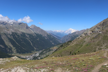
Depart from Cogne and, at the end of the village before the bridge, take the farm road to the right ( orographic left of the d'Urtier stream) that in 4 km leads to Lillaz where you cross again at the first bridge and ascend into the Urtier valley to the east; signs at the beginning of the ascent indicate trail 10 with its declinations, 10C Seutse and Taveronna and Colonna mine, 10D Invergneux, 10F Window of Champorcher. Ascend on shaded asphalt to the Cret chapel q.2016 and again on wide dirt road with paved sections, the streams in July are a wonder, swollen and thunderous. The sign for Taveronna is evident at elevation 2,261 after about 12 km from the start. We then ascend by retracing the outward road at altitude in a westerly direction on a wide mule track, on the edge a rainbow of flowers from bright purple alpine asters to arnica yellow, below pastures and in the background views of the Grivola and then, near the Gran Paradiso and M.Bianco mines; we reach the Taveronna alpine pasture at an altitude of 2351 downhill and then continue on a marked trail that is almost entirely cyclable except for short stretches to be done on foot.
The history of the mine, which can be visited only with a guide and by reservation, also appears on the Valle d'Aosta tourism website; around M.Creya, a three-thousand-meter peak above, were other mining stations, Liconi, Larsinaz and Costa del Pino.
The descent is hairpin turns, first part debris hill, second part forest: trail 5 is initially trialistic with tight switchbacks, slippery bottom, water drainage logs after turns, no precipices or overhangs. In the forest track flow, stones and roots alternate on firm ground with some technical and stepped passages. Only two well-marked forks with yellow signs follow, 7a to Champlong and 5a to Montroz; the easier trail 5, however, continues to Moline. The hamlet is a few hundred meters from Cogne; return on asphalt to the parking lot.
The Hiker Publisher No. 10 Valle di Cogne Gran Paradiso Trail Map (1:25,000)