Italiano
 Deutsch
Colle dell'Invergneux da Cogne

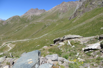
We start from Cogne (altitude about 1,520), cross the village and after about 1 km turn right onto an easy forest road slightly uphill that leads to Lillaz. Here, at an altitude of 1,610, cross the bridge over the Grand'Eyvia stream and take the opposite road with signposts (marker No. 10 for Invergneux Pass , Rifugio Sogno and also Colonna Mine). The road climbs on an asphalt surface with hairpin bends up to an altitude of 1,870, then the dirt road begins, with an up and down you pass the village of Goille, the Chapel of the Alpini (altitude of about 2,020), avoid the detour to the left for the Dzoelaz Alp, and enter the plateau of the Urtier valley. After a short section in the Urtier plain at an altitude of 2,350, turn left following the 10D trail markers and continue uphill toward Lac Ponton and the Invergneux pass. The climb remains rideable on a dirt surface until an altitude of about 2,650 where the real portage begins, which becomes even more strenuous in the final part; you cross the scree that precedes the window where a stone "little man" heralds the end of your labors. At an altitude of 2,903 the Invergneux is reached!
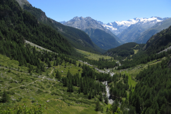
Time to look around and on the valley floor with a glimpse of the road traveled and the splendid descent into the Grauson valley begins: a trail descends into the green pastures of the valley with moderate difficulty except for a couple of sections on rock preceding the huts of the alp of the same name. Next comes a more difficult section, still on rock, with narrow and not very smooth passages before reaching at an altitude of 1,940 at the bridge over the stream. Cross it to the opposite side and go slightly up in altitude with a short push section on a steep path and start descending again in the direction of Gimillan. When we reach the village we find a path - shortcut that reconnects to the asphalt road of the communal road of Lillaz that leads back to the entrance of Cogne.