Italiano
 Deutsch
Cima Terre Fredde, Val Braone, Passo Frerone, Val Fredda, Monte Trabucco
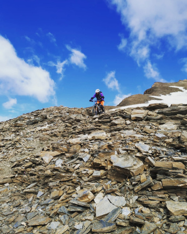
Strictly cycloalpine loop tour, very challenging and strenuous, suitable only for very uncomfortable cycloalpinists with significant cyclo-social challenges. Many pushing and backpacking sections, especially the climb from Cow Lake to Terre Fredde summit, there is no trail and there is climbing over very steep terrain with scree and grass, to be very careful.
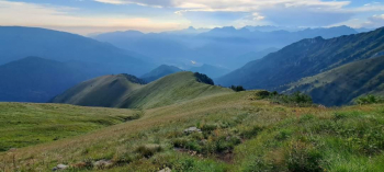
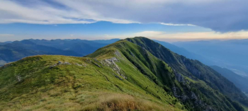
That said, great high mountain environment, sublime views. Various descents all very beautiful and challenging (maximum S3). First short downhill section from Frerone Pass not cyclable. In short, if advanced cyclo-discomfort does not bother you, in fact it exhilarates you, this is your ride, get ready to experience something extraordinary.
To reach the starting point go up the lower Valcamonica along the freeway, exit Esine, Berzo Inferiore, Bienno. Reach Bienno and then climb in the direction of Passo di Crocedomini to Campolaro.
Depart Campolaro, 1450 m, parking along the road. Ascend in the direction of Crocedomini Pass. Two options: a) for those who want to avoid the bitumen like the plague, follow the signs to the right for Bazena (first section you pedal, then trail all the way up to the meadows below the Tassara refuge, where you pedal up to the asphalt road); b) follow the asphalt as the bitumarians do. From Bazena inexorably on bitumen, passing through the Crocedomini pass you reach the Cadino schooner. The following short descent is tackled by cutting the four hairpin bends by trail tracks in the grass, Past Malga Cadino turn left going up the little white road and then the typical granite paved road (steep stretches pushing with the muscular) to Passo della Vacca, 2361 meters.
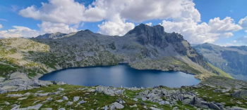
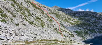
Here turn left (those who wish can reach the Tita Secchi refuge a few minutes) to the Vacca Lake where you turn left into wild and "unexplored" territories. There is no path, although marked on the map, you must climb following the track on the map, by logic and feeling. After a couple of crags one reaches a wide, slightly sloping granite plateau, at the base one must inexorably climb (to the left) up very steep scree and equally steep grassy slopes, avoiding the menacing blocks hovering overhead (be very careful where you put your feet and where you stick your hands, moving stones).
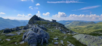
Reaching a ridge (cairn) on less challenging terrain, traverse (cairns here and there) aiming for the wide saddle with large stone cairn, between the Galliner and Terre Fredde peaks. The last part of the ascent with bike on shoulder does not present particular difficulties. Beware, it is possible to avoid this section by climbing in the direction of the Blumone pass and riding along the ridge that divides the amphitheater of Lago della Vacca with the Listino basin up to Cima Gallinera, then rejoining the saddle between the two peaks (longer but less difficult).
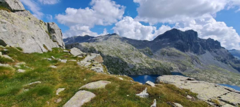
From the Terre Fredde peak, 2645 meters, descend the exciting military trail to the Forcellino della Mare, 2191 meters. Now in a short time it is possible to descend to the idyllic Gheza refuge or as I did follow the yellow and white markings (Antonioli trail) to the mouths of Val Braone, just above the refuge.
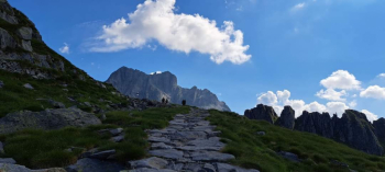
Admiring the magical environment weighs less the push and shoulder climb up to Frerone Pass, 2445 meters. The first steep part of the descent from the pass (70 meters of elevation gain) is not cyclable. Confluent on trail number 1 you reach on the pedals the Bocchetta di Val Fredda (very short push uphill) then descending with enjoyment to the Malga Val Fredda, 2050 meters. Turning right, you reach on a small road the Malga Valbona hut where the path begins that, bike on shoulder, leads to the beginning of the spectacular long ridge of Monte Trabucco.
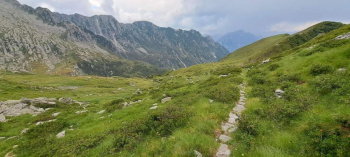
Having satisfactorily reached the panoramicissine peak, at 2230 meters begins the beautiful descent on a grassy ridge (be careful) that leads to the ridge of Plan del Zuf, where at an altitude of 1600 meters, turning left, begins the last beautiful path that descends to Campolaro, the starting point.