
 Italiano
 Deutsch
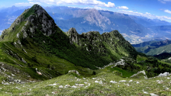
Monte Campedelli, Monte Alta Guardia
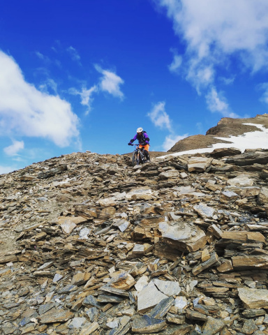
It was a missing piece of my cycloalpine exploration in the Camuni Mountains. The environment and views are first-rate, Habsburg cyclo-discomfort, due to very steep sections of ascent along the beautiful Stabio Valley, the 400 meters of elevation gain with bike on shoulder on steep inclines (BEWARE!), but especially due to several extremely wild parts of trail (some traverse logs and lush vegetation) along the interminable descent.
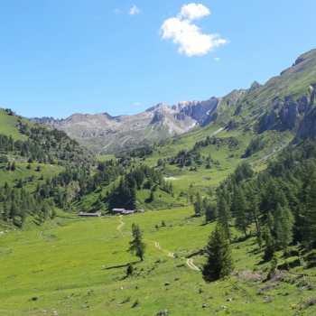
Departure from Breno, via C. Tassara, parking lot by the train station. Heading toward the center, go to take Provincial Road 345 to the Crocedomini Pass. Passing first by Pescarzo and then by Astrio, one rejoins the road that climbs from Bienno. Past the houses of Degna, after the second hairpin bend, ahead 100-200 meters, on the left begins the forest road that leads first to Pian d'Astrio and then to Val di Stabio. The first part, though steep, is very rideable, the second part becomes more deadly but once you come out near Malga Stabio di Sotto, the gates of Paradise open wide.
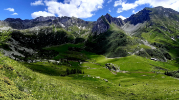
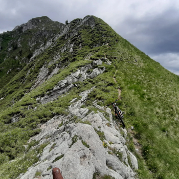
When you reach Malga di Stabio di Sopra (going straight on would take you up to the Porte di Stabio, 2,500 meters, and the peak of the same name, 2,550 meters, and then down into Val Braone, but that's another route), at a post with signposts, you turn left, by faint tracks and faded markings. In the meadow you must skirt the stream to a rocky island in the green, where you cross it on the left with a small ford. Back to the creek and bike on your back you climb to the maximum incline, finding the red and white markers pointing to the fairly obvious trail that passes under a rocky outcrop. You ascend it, being careful not to get off the trail, which here occasionally needs to be looked for (not very busy). Gradually the slopes become steeper and steeper, you need to proceed with sure footing. Just before Passo dei Sabbioni turn left, being careful not to get too high. A last half-steep leads to Mount Campedelli, 2273 meters, the summit of the day.
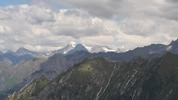
After admiring the great view, you must continue along the airy ridge heading east. It is downhill but you tackle it mostly on foot, passing by Passo del Muro to Bocchetta di Somale, 2155 meters. Here you leave the bike to tackle the last steep 70 meters that lead to the summit cross Monte Alta Guardia, 2226 meters.
Back at the Bocchetta, in descent gear you descend on foot down the first very steep meters on trail marker. Just before the wooden marker post you can strap on your bike and very carefully, somehow, without an obvious obligatory route you descend to the basin below and following the markers you reach the Campedelli Alta malga.
Cross the meadow and descend along the former mule track that has now become a wide path, somewhat uneven in places. Without any particular problems we descend to an altitude of about 1580 meters, where a recent signpost indicates on the left the path to Pian d'Astrio.
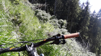
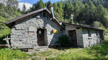
And here the real big discomfort begins, not so much for the hundred or so meters of positive elevation gain gradually to be made up but for the wild "descent" (so to speak) that follows, where the Vaia storm has hit (the path has been restored but a few logs to climb over and a few more to pass under are there and brambles, ferns, grass and nettles have grown up). When you finally manage to stay on your bike you arrive at the Malga Sambuco bivouac, 1460 meters.
Leaving the bivouac, descending into the little valley below, just below you come to a fork in the road: on the left you go toward Pian d'Astrio (to be avoided) on the right you continue the descent, which now becomes steep on a narrow path through the woods (pine needles) in hairpin bends. For a good stretch you manage to stay on the bike with various nosepresses and precise trajectories, until you still encounter some wild or too steep, narrow, and rocky sections that force you to get off the bike a few times. My idea was to go to Argai to descend to Breno on nice trails but the path marked on the maps no longer exists, encompassed in the forest vegetation. Arriving on a former small road, now reduced to a trail, quickly (only one tree to climb over) we arrive in Niardo. Now all that remains is to return to the starting point in Breno


