Italiano
 Deutsch
Punta Sommelier, Truc Peyrous, Cima del Vallonetto e Seguret

The route follows almost entirely that of Lazzadielle 's Punta Sommelier.
Starting in Rochemolles, climb up the dirt road to the Sommelier pass (closed to traffic only on Thursdays) with slopes that are never too steep up to 2650mt. From here take a trail that you climb by pushing and/or shouldering, reaching first the Forneaux pass and then the summit of Sommelier (3333). Incredible 360° panorama.
The descent starts a bit steep on a bumpy surface then flattens out turning towards the Forneaux pass. All bikeable except for a few short steps to avoid some boulders on the trail.
From the pass continue downhill to the Galambra shelter, where you leave the Lazzadielle trail, and instead of descending to Val Fredda you climb briefly on a comfortable trail pedaling and pushing to Truc Peyrous (3185) with views of the glaciers further north and the Susa Valley. Continue with an up and down freeride ridge climb to Cima di Vallonetto (3217). The last few meters to reach the summit have a short equipped and very exposed section. (I was able to get through it even though I was alone but it took some slack).
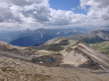
From the Cima del Vallonetto the view of the descent and the valley below is breathtaking. I don't know if anyone has ever biked down this way.
At the start you manage a few meters in the saddle with a vertical and technical section where you need nose press and good technique. Then with a spirit of conservation you descend in deportage to 3100m. Now begins a challenging but beautiful descent on slippery terrain past the Vallonetto lakes. There is a bit of everything here: switchbacks, freeride on tiles and flow sleepers.
Once you reach the Vin Vert shelter you climb back up to Seguret. Very rideable climb initially until the final traverse that leads to the Argentera Pass (2780). Continue up to the Seguret cross (I abandoned the bike a few meters below always out of a spirit of conservation).
You retrace your steps and the descent is once again magnificent and fast to the Vin Vert shelter. You then continue to descend into the valley towards the Seguret Cave Barracks. When we reach the dirt road I recommend a small detour to the left to see the beautiful Seguret caves and refuel with water.
We take the dirt road again to Fort Föens where we take a beautiful single track through the woods. Hyperspeed over soft ground and roots (watch out for hairpin bends that come out of nowhere) to Rochas. We briefly climb up the asphalt and start again a beautiful up and down on single track until Rochemolles.
In conclusion a fabulous ride for views, environments, descents and track intuition (thanks to Lazzadielle).