2023/03/07 22:24:35
Plan de Corones freeride
Author
Place
Italy - Trentino-Alto Adige/Südtirol, BZ
Km
28,90 km
Elapsed time
02:11:27
Vertical meters
0 mt (930 - 2293)
Route difficulty
Landscapes
Last update
2023/03/09 10:26:01
Comments
Description
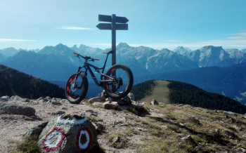
You go up to Plan de Corones with the lifts and have three nice descents on specially prepared trails reserved for mountain bikes. The first towards Valdaora, a completely flow track, where you just need to know how to turn the bike around corners, the rest is all smooth. The second to Passo Furcia, also flowing but with some extra difficulty, a few steep sections and some more challenging variants.

The third is the classic Herrensteig, the most challenging trail, very long, with steep sections and a few drops, also challenging, however always passable on the side.
This in 2017, more trails will be added soon, all with a single day pass.
Local weather

°C

°C

°C

°C

°C

°C
Graph
Nearest Routes
66,23 km
Km
+2 220 mt
Vertical meters
Route difficulty
Landscapes
46,45 km
Km
+1 450 mt
Vertical meters
Route difficulty
Landscapes
23,05 km
Km
+1 600 mt
Vertical meters
Route difficulty
Landscapes
49,31 km
Km
+1 700 mt
Vertical meters
Route difficulty
Landscapes
27,87 km
Km
+1 571 mt
Vertical meters
Route difficulty
Landscapes
2023/03/05
- Italy - Trentino-Alto Adige/Südtirol, BZ 45,98 km
Km
+1 400 mt
Vertical meters
Route difficulty
Landscapes
40,94 km
Km
+2 230 mt
Vertical meters
Route difficulty
Landscapes
34,62 km
Km
+1 720 mt
Vertical meters
Route difficulty
Landscapes
36,75 km
Km
+1 837 mt
Vertical meters
Route difficulty
Landscapes
45,86 km
Km
+1 661 mt
Vertical meters
Route difficulty
Landscapes


 Italiano
 Deutsch