HOME RANKINGS CHALLENGES ROUTES NEAR ME PLANNING SEARCH LOGIN
Italy - Trentino-Alto Adige/Südtirol, BZ
2023/03/07 22:04:00

Sambock e sentiero 66

102 Downloads
8
 
Share

Key Takeaways / Scheda Tecnica

Disciplina:
Mountain Bike (MTB)
Percorso:
Sambock e sentiero 66
Località:
Italy - Trentino-Alto Adige/Südtirol, BZ
Distanza:
23,05 km
Dislivello Positivo:
+1 600 mt (Quota Min: 843m - Max: 2394m)
Difficoltà Tecnica:
5/5
Valutazione Panorami:
4/5
Formato Traccia:
GPX Download disponibile
Author
nonnocarb
(324)
Place
Italy - Trentino-Alto Adige/Südtirol, BZ
Km
23,05 km
Elapsed time
04:52:16
Vertical meters
+1 600 mt (843 - 2394)
Route difficulty
Landscapes
Last update
2026/08/11 21:41:49
Comments
2
Description

A very challenging route—more uphill than downhill, to be honest—since Trail 66, known for its difficulty, has been almost completely cleared; in fact, only a few challenging sections remain, with roots and rocks, in addition to the final stretch.
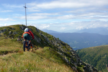
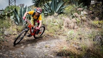
Foto itinerario MTB Sambock e sentiero 66 - Italy - Trentino-Alto Adige/Südtirol, BZ

The climb is long but not particularly challenging until the end of the rideable section; after that, however, you’ll have to carry your bike for half an hour over ridges that are very difficult to navigate and sections requiring the use of the chain.

Foto itinerario MTB Sambock e sentiero 66 - Italy - Trentino-Alto Adige/Südtirol, BZ

This brings you to the summit of Mount Sambock, with a beautiful view. From here, it’s a super-flow descent on Trail 66, with a few challenging sections—especially the final stretch—all the way down to the valley. Alternatively, from the last mountain hut, take the forest road to the left and then push on to the summit of Sambock via the descent trail, which will definitely save you time and energy.


Download our free mobile app to send this route to your Garmin device or to navigate it on OSM maps. Android - iOS
Local weather
Tue 00:00
10 °C
Tue 12:00
13 °C
Wed 00:00
12 °C
Wed 12:00
13 °C
Thu 00:00
12 °C
Thu 12:00
9 °C
Fri 00:00
4 °C
Fri 12:00
8 °C
Sat 00:00
6 °C
Sat 12:00
6 °C

Graph

Nearest Routes

2023/03/05
- Italy - Trentino-Alto Adige/Südtirol, BZ
nonnocarb
(324)
66,23 km
Km
+2 220 mt
Vertical meters
Route difficulty
Landscapes
2023/03/04
- Italy - Trentino-Alto Adige/Südtirol, BZ
nonnocarb
(324)
46,45 km
Km
+1 450 mt
Vertical meters
Route difficulty
Landscapes
2023/03/07
- Italy - Trentino-Alto Adige/Südtirol, BZ
nonnocarb
(324)
28,90 km
Km
0 mt
Vertical meters
Route difficulty
Landscapes
2023/03/06
- Italy - Trentino-Alto Adige/Südtirol, BZ
nonnocarb
(324)
49,31 km
Km
+1 700 mt
Vertical meters
Route difficulty
Landscapes
2023/03/04
- Italy - Trentino-Alto Adige/Südtirol, BZ
giobike73
(49)
36,75 km
Km
+1 837 mt
Vertical meters
Route difficulty
Landscapes
2024/07/22
- Italy - Trentino-Alto Adige/Südtirol, BZ
nonnocarb
(324)
31,43 km
Km
+1 830 mt
Vertical meters
Route difficulty
Landscapes
2023/03/05
- Italy - Trentino-Alto Adige/Südtirol, BZ
nonnocarb
(324)
45,98 km
Km
+1 400 mt
Vertical meters
Route difficulty
Landscapes
2022/09/21
- Italy - Trentino-Alto Adige/Südtirol, BZ
27,87 km
Km
+1 571 mt
Vertical meters
Route difficulty
Landscapes
2024/07/24
- Italy - Trentino-Alto Adige/Südtirol, BZ
steve-U
(29)
40,94 km
Km
+2 230 mt
Vertical meters
Route difficulty
Landscapes
2023/03/07
- Italy - Trentino-Alto Adige/Südtirol, BZ
nonnocarb
(324)
34,62 km
Km
+1 720 mt
Vertical meters
Route difficulty
Landscapes

2 Comments