HOME RANKINGS CHALLENGES ROUTES POI PLANNING SEARCH LOGIN
Italy - Trentino-Alto Adige/Südtirol, BZ
2023/03/07 17:43:00

Sass Putia

33 Downloads
4
 
Author
nonnocarb
(266)
Place
Italy - Trentino-Alto Adige/Südtirol, BZ
Km
34,62 km
Elapsed time
07:49:28
Vertical meters
+1 720 mt (1162 - 2813)
Route difficulty
Landscapes
Last update
2023/03/09 08:56:05
Comments
7
Description

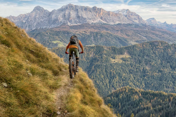
Very challenging itinerary, for experienced and very trained bikers, with a backpacking bike section of about an hour to get to the top of Sass Putia (small).

Incredible views and very fun though very challenging descents with walking sections. From S. Martino in Badia climb up the beautiful Longiarù valley to the Furcia pass with steep sections. From here a short push section, then pedal on the beautiful trail with wonderful views to the Poma Pass and Putia Fork.

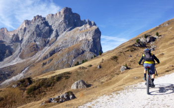
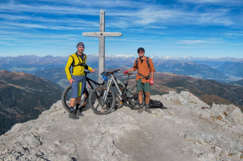
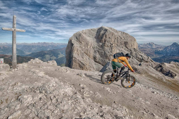
Now bike up, with short pedaled sections, to the summit cross, with unique views. On the descent, however, with good technique you can almost always stay in the saddle. Back at the Putia fork, you descend the path even more technical, with a few landslide sections.

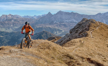
At the fork you take a right to Passo delle Erbe on a nice trail, then up to Goma Pass with one last push section. Arriving at the pass we have gone almost all the way around Putia and descend on trail 9, initially very narrow and with exposed sections, be careful.

Then the trail widens and you can quickly descend to St. Martin. Incredibly beautiful tour.

Download our free mobile app to send this route to your Garmin device or to navigate it on OSM maps. Android - iOS

Graph

Nearest Routes

2023/03/06
- Italy - Trentino-Alto Adige/Südtirol, BZ
nonnocarb
(266)
49,31 km
Km
+1 700 mt
Vertical meters
Route difficulty
Landscapes
2022/09/21
- Italy - Trentino-Alto Adige/Südtirol, BZ
27,87 km
Km
+1 571 mt
Vertical meters
Route difficulty
Landscapes
2022/08/04
- Italy - Trentino-Alto Adige/Südtirol, BZ
gmzolenart
(104)
17,91 km
Km
+830 mt
Vertical meters
Route difficulty
Landscapes
2023/02/26
- Italy - Trentino-Alto Adige/Südtirol, BZ
nonnocarb
(266)
24,35 km
Km
+700 mt
Vertical meters
Route difficulty
Landscapes
2023/02/26
- Italy - Trentino-Alto Adige/Südtirol, BZ
nonnocarb
(266)
26,13 km
Km
+960 mt
Vertical meters
Route difficulty
Landscapes
2023/02/26
- Italy - Trentino-Alto Adige/Südtirol, BZ
nonnocarb
(266)
25,21 km
Km
+880 mt
Vertical meters
Route difficulty
Landscapes
2023/08/20
- Italy - Trentino-Alto Adige/Südtirol, BZ
14,28 km
Km
+900 mt
Vertical meters
Route difficulty
Landscapes
2023/02/26
- Italy - Trentino-Alto Adige/Südtirol, BZ
nonnocarb
(266)
16,43 km
Km
+510 mt
Vertical meters
Route difficulty
Landscapes
2023/03/04
- Italy - Trentino-Alto Adige/Südtirol, BZ
nonnocarb
(266)
33,04 km
Km
+2 120 mt
Vertical meters
Route difficulty
Landscapes
2023/03/07
- Italy - Trentino-Alto Adige/Südtirol, BZ
nonnocarb
(266)
28,90 km
Km
0 mt
Vertical meters
Route difficulty
Landscapes

7 Comments