HOME RANKINGS CHALLENGES ROUTES POI PLANNING SEARCH LOGIN
Italy - Trentino-Alto Adige/Südtirol, BZ
2023/03/05 10:22:31

Forcella Grubl (forcella della Fossa)

11 Downloads
2
 
Author
nonnocarb
(266)
Place
Italy - Trentino-Alto Adige/Südtirol, BZ
Km
45,98 km
Elapsed time
05:11:43
Vertical meters
+1 400 mt (1020 - 2393)
Route difficulty
Landscapes
Last update
2023/03/06 08:01:37
Comments
0
Description

Beautiful route, off the beaten path and off the beaten track, from the Casies Valley to the Antholz Valley via the Grubl Fork, or Fossa Fork.

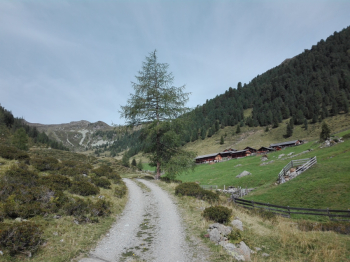
It starts in Rasun di sotto and reaches Monguelfo. You go up into the Casies valley and on a bicycle path to Planca di sopra.

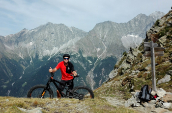
Here begins the long, initially very steep ascent on a forest road into the Karbach valley. You pedal up to the Ochsenfelder farms at 2014 meters, then to the fork at 2594 meters you follow an old military trail, about 50 percent rideable, on e-bike almost completely. The environment is wild and quiet; on the left you can see the Ampertorl, Somma's fork, also reachable by pedaling on a military road, but on the other side.

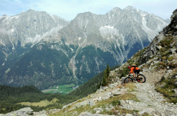
The view from the fork is beautiful, and we are also in for a welcome surprise, the path down is in fact perfectly maintained and cyclable, again on an old military path. The fun continues until the 2038 meters of the Grublalm, then we take trail 8 and here instead things get more challenging, the trail is narrow with several pushing sections on the way up. Wanting to descend more simply, just follow Trail 9 to the valley floor instead. At the end of trail 8, a section of forestry and then it's downhill again on trail, this time fun and cyclable, though technical. When you reach the bottom of the valley, you follow the beautiful bike path to the end of the Antholz Valley.

Download our free mobile app to send this route to your Garmin device or to navigate it on OSM maps. Android - iOS

Graph

Nearest Routes

2022/10/22
- Italy - Trentino-Alto Adige/Südtirol, BZ
nonnocarb
(266)
45,86 km
Km
+1 661 mt
Vertical meters
Route difficulty
Landscapes
2023/03/04
- Italy - Trentino-Alto Adige/Südtirol, BZ
nonnocarb
(266)
46,45 km
Km
+1 450 mt
Vertical meters
Route difficulty
Landscapes
2023/03/05
- Italy - Trentino-Alto Adige/Südtirol, BZ
nonnocarb
(266)
66,23 km
Km
+2 220 mt
Vertical meters
Route difficulty
Landscapes
2023/03/07
- Italy - Trentino-Alto Adige/Südtirol, BZ
nonnocarb
(266)
28,90 km
Km
0 mt
Vertical meters
Route difficulty
Landscapes
2023/03/07
- Italy - Trentino-Alto Adige/Südtirol, BZ
nonnocarb
(266)
23,05 km
Km
+1 600 mt
Vertical meters
Route difficulty
Landscapes
2022/09/21
- Italy - Trentino-Alto Adige/Südtirol, BZ
27,87 km
Km
+1 571 mt
Vertical meters
Route difficulty
Landscapes
2023/02/26
- Italy - Trentino-Alto Adige/Südtirol, BZ
nonnocarb
(266)
53,06 km
Km
+220 mt
Vertical meters
Route difficulty
Landscapes
2023/03/04
- Italy - Trentino-Alto Adige/Südtirol, BZ
nonnocarb
(266)
37,05 km
Km
+1 550 mt
Vertical meters
Route difficulty
Landscapes
2023/02/26
- Italy - Trentino-Alto Adige/Südtirol, BZ
nonnocarb
(266)
35,05 km
Km
+505 mt
Vertical meters
Route difficulty
Landscapes
2023/03/01
- Italy - Trentino-Alto Adige/Südtirol, BZ
nonnocarb
(266)
76,61 km
Km
+2 400 mt
Vertical meters
Route difficulty
Landscapes

0 Comments