HOME RANKINGS CHALLENGES ROUTES NEAR ME PLANNING SEARCH LOGIN
Italy - Trentino-Alto Adige/Südtirol, BZ
2023/03/05 08:21:21

Denti di Cavallo e Castelchiaro di Monticolo

7 Downloads
0
 
Share

Key Takeaways / Scheda Tecnica

Disciplina:
Mountain Bike (MTB)
Percorso:
Denti di Cavallo e Castelchiaro di Monticolo
Località:
Italy - Trentino-Alto Adige/Südtirol, BZ
Distanza:
40,59 km
Dislivello Positivo:
+770 mt (Quota Min: 0m - Max: 615m)
Difficoltà Tecnica:
3/5
Valutazione Panorami:
3/5
Formato Traccia:
GPX Download disponibile
Author
nonnocarb
(324)
Place
Italy - Trentino-Alto Adige/Südtirol, BZ
Km
40,59 km
Elapsed time
04:48:17
Vertical meters
+770 mt (0 - 615)
Route difficulty
Landscapes
Last update
2023/03/06 07:51:30
Comments
0
Description

Very varied and scenic tour, at low altitudes therefore practicable all year round, with many fun trails and forest roads, but also challenging due to many hard though short climbs.
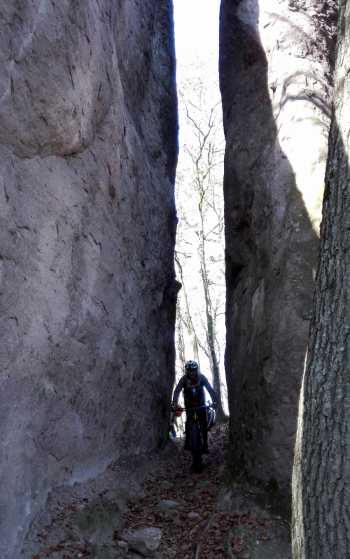
Foto itinerario MTB Denti di Cavallo e Castelchiaro di Monticolo - Italy - Trentino-Alto Adige/Südtirol, BZ

We climb first on bike path to Eppan, then in the woods to Monticolo. From here we take the beautiful spring valley (attention bike ban, practicable only in winter or out of season) to Lake Kaltern. Then we climb up to the ruins of Castelchiaro with last push section with beautiful views.

Foto itinerario MTB Denti di Cavallo e Castelchiaro di Monticolo - Italy - Trentino-Alto Adige/Südtirol, BZ

We descend and a nice pedaled path with steep sections takes us up to the characteristic horsetooth, with nice views of the Adige valley. A technical downhill section, then back to the Monticolo lakes on forestry. We skirt the beautiful lakes and on forest trails descend to Firmiano Castle (Messner museum) and the start .
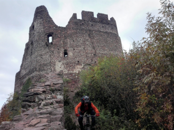
Foto itinerario MTB Denti di Cavallo e Castelchiaro di Monticolo - Italy - Trentino-Alto Adige/Südtirol, BZ.

Download our free mobile app to send this route to your Garmin device or to navigate it on OSM maps. Android - iOS
Local weather
Tue 00:00
13 °C
Tue 12:00
16 °C
Wed 00:00
15 °C
Wed 12:00
15 °C
Thu 00:00
13 °C
Thu 12:00
14 °C
Fri 00:00
9 °C
Fri 12:00
11 °C
Sat 00:00
11 °C
Sat 12:00
14 °C

Graph

Nearest Routes

2023/03/04
- Italy - Trentino-Alto Adige/Südtirol, BZ
nonnocarb
(324)
61,68 km
Km
+1 220 mt
Vertical meters
Route difficulty
Landscapes
2023/05/22
- Italy - Trentino-Alto Adige/Südtirol, BZ
Robibz
(25)
43,62 km
Km
+1 392 mt
Vertical meters
Route difficulty
Landscapes
2023/03/04
- Italy - Trentino-Alto Adige/Südtirol, BZ
nonnocarb
(324)
34,77 km
Km
+1 200 mt
Vertical meters
Route difficulty
Landscapes
2023/08/07
- Italy - Trentino-Alto Adige/Südtirol, BZ
Simo Rad
(1)
65,12 km
Km
+2 370 mt
Vertical meters
Route difficulty
Landscapes
2022/10/28
- Italy - Trentino-Alto Adige/Südtirol, BZ
Robibz
(25)
37,02 km
Km
+900 mt
Vertical meters
Route difficulty
Landscapes
2023/02/26
- Italy - Trentino-Alto Adige/Südtirol, BZ
nonnocarb
(324)
47,05 km
Km
+1 480 mt
Vertical meters
Route difficulty
Landscapes
2023/09/25
- Italy - Trentino-Alto Adige/Südtirol, BZ
Robibz
(25)
20,41 km
Km
+780 mt
Vertical meters
Route difficulty
Landscapes
2023/03/17
- Italy - Trentino-Alto Adige/Südtirol, BZ
Robibz
(25)
20,32 km
Km
+400 mt
Vertical meters
Route difficulty
Landscapes
2023/03/25
- Italy - Trentino-Alto Adige/Südtirol, BZ
Robibz
(25)
47,22 km
Km
+1 707 mt
Vertical meters
Route difficulty
Landscapes
2023/06/02
- Italy - Trentino-Alto Adige/Südtirol, BZ
Robibz
(25)
40,24 km
Km
+3 321 mt
Vertical meters
Route difficulty
Landscapes

0 Comments