HOME RANKINGS CHALLENGES ROUTES POI PLANNING SEARCH LOGIN
Italy - Trentino-Alto Adige/Südtirol, BZ
2023/08/07 16:12:00

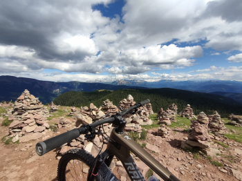
Omini di Pietra (Stoanerne Mandln)

6 Downloads
1
 
Author
Simo rad
(1)
Place
Italy - Trentino-Alto Adige/Südtirol, BZ
Km
65,12 km
Elapsed time
11:22:56
Vertical meters
+2 370 mt (293 - 2042)
Route difficulty
Landscapes
Last update
2023/08/07 16:51:19
Comments
0
Description

Fantastic as well as challenging route. Very challenging ascent, it takes good training and technical descent S2- S3 with S4 passages in the last descent. Not recommended in summer put-ons, better spring or fall.

Climb along the state highway to San Genesio to the junction to Cologna. Bring a back light as there are tunnels. Be very careful because the road is very busy.

Once at the junction continue on asphalt road to Gasthof Locher, from here the forest road begins on the Salten Plateau. After that continue in the direction of Möltner Kaser between steep paths and meadows. Once you reach the hut that lies at the foot of the peak, the last ascent to the "Stoanerne Mandln" begins, which is located at about 2100 meters. For those who still have legs and breath you pedal up the steep trail.

When you reach the top you have a spectacular 360-degree view.

The descent begins on the opposite side of the ascent, first in the direction of Sarenthein, a fun trail with steps, and afterwards in the direction of Hausberg through the forest and then back on the path to the Möltner Kaser. Once back at the hut follow the signs first to the Salten and then to the Tschaufenhaus hut, pedaling for about 1:30h.

When you arrive at the Tschaufenhaus, you follow the signs toward Terlan, from here the last technical descent to Vilpian begins, first on trail NR 7 and then 1B. You come out in Vilpiano, from here you pedal along the state highway towards Bolzano.

PS: Between NR 7 and 1B, I took the wrong route. I pedaled back to the trailhead of trail 1B. Pay attention and read the signs.

Download our free mobile app to send this route to your Garmin device or to navigate it on OSM maps. Android - iOS

Graph

Nearest Routes

2023/03/05
- Italy - Trentino-Alto Adige/Südtirol, BZ
nonnocarb
(266)
40,59 km
Km
+770 mt
Vertical meters
Route difficulty
Landscapes
2023/03/04
- Italy - Trentino-Alto Adige/Südtirol, BZ
nonnocarb
(266)
34,77 km
Km
+1 200 mt
Vertical meters
Route difficulty
Landscapes
2023/03/04
- Italy - Trentino-Alto Adige/Südtirol, BZ
nonnocarb
(266)
61,68 km
Km
+1 220 mt
Vertical meters
Route difficulty
Landscapes
2023/05/22
- Italy - Trentino-Alto Adige/Südtirol, BZ
Robibz
(19)
43,62 km
Km
+1 392 mt
Vertical meters
Route difficulty
Landscapes
2022/10/28
- Italy - Trentino-Alto Adige/Südtirol, BZ
Robibz
(19)
37,02 km
Km
+900 mt
Vertical meters
Route difficulty
Landscapes
2023/09/25
- Italy - Trentino-Alto Adige/Südtirol, BZ
Robibz
(19)
20,41 km
Km
+780 mt
Vertical meters
Route difficulty
Landscapes
2023/03/17
- Italy - Trentino-Alto Adige/Südtirol, BZ
Robibz
(19)
20,32 km
Km
+400 mt
Vertical meters
Route difficulty
Landscapes
2023/03/25
- Italy - Trentino-Alto Adige/Südtirol, BZ
Robibz
(19)
47,22 km
Km
+1 707 mt
Vertical meters
Route difficulty
Landscapes
2023/06/02
- Italy - Trentino-Alto Adige/Südtirol, BZ
Robibz
(19)
40,24 km
Km
+3 321 mt
Vertical meters
Route difficulty
Landscapes
2023/02/26
- Italy - Trentino-Alto Adige/Südtirol, BZ
nonnocarb
(266)
47,05 km
Km
+1 480 mt
Vertical meters
Route difficulty
Landscapes

0 Comments