HOME RANKINGS CHALLENGES ROUTES POI PLANNING SEARCH LOGIN
Italy - Trentino-Alto Adige/Südtirol, BZ
2023/06/02 22:07:05

Bolzano - Unterhorn (Renon) - Campodazzo

11 Downloads
1
 
Author
Robibz
(19)
Place
Italy - Trentino-Alto Adige/Südtirol, BZ
Km
40,24 km
Elapsed time
08:19:02
Vertical meters
+3 321 mt (322 - 2154)
Route difficulty
Landscapes
Last update
2023/06/05 21:21:36
Comments
4
Description

Very nice tour but also very tiring.

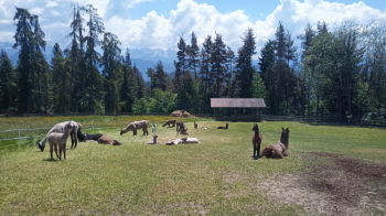
We start from Bolzano, in the direction of Sill, from here we start to climb in the direction of Renon (at a certain point we will meet a gate with a sign warning us that it is forbidden to pass because of private property, that sign has no value as it is a public road and also the gate could not exist, cmq we pass easily to the left), the first part on asphalt and the second part on dirt road (very tiring). Arriving in Soprabolzano we get a fantastic view of the Dolomites and still in that village, following the track, we pass by a farm that has made alpacas its main attraction

We continue along the ascent until we reach Pemmern, from here we can eventually decide to take the gondola that saves us about 500 meters of elevation gain or continue following the trail, the climb is never too challenging except just before we reach the plateau.

When you arrive at the Unterhorn hut you can refresh yourself (they make gigantic Viennese-style cutlets) and rest a bit after doing about 1850 meters of positive elevation gain, or you can decide to go to the top of the Rittner Horn doing another 200 meters of elevation gain, needless to say that the view from the top is spectacular (today unfortunately there was bad weather in the Dolomites).

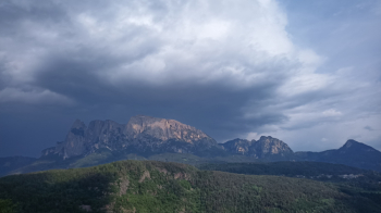
From the Unterhorn hut starts the 1900-meter descent almost all on trail. The difficulties are, in my opinion, S2 with a few S3 passages. Halfway down you can admire the Sciliar in all its beauty and grandeur, at times it almost feels like you can touch it.

Once in the valley we take the bike path, which is on the opposite side of the road, that takes us back to Bolzano (it is about 15 km).

Download our free mobile app to send this route to your Garmin device or to navigate it on OSM maps. Android - iOS

Graph

Nearest Routes

2023/03/25
- Italy - Trentino-Alto Adige/Südtirol, BZ
Robibz
(19)
47,22 km
Km
+1 707 mt
Vertical meters
Route difficulty
Landscapes
2023/03/17
- Italy - Trentino-Alto Adige/Südtirol, BZ
Robibz
(19)
20,32 km
Km
+400 mt
Vertical meters
Route difficulty
Landscapes
2023/09/25
- Italy - Trentino-Alto Adige/Südtirol, BZ
Robibz
(19)
20,41 km
Km
+780 mt
Vertical meters
Route difficulty
Landscapes
2023/03/01
- Italy - Trentino-Alto Adige/Südtirol, BZ
nonnocarb
(266)
48,48 km
Km
+1 910 mt
Vertical meters
Route difficulty
Landscapes
2023/03/04
- Italy - Trentino-Alto Adige/Südtirol, BZ
nonnocarb
(266)
27,65 km
Km
+1 100 mt
Vertical meters
Route difficulty
Landscapes
2023/03/04
- Italy - Trentino-Alto Adige/Südtirol, BZ
nonnocarb
(266)
48,93 km
Km
+2 000 mt
Vertical meters
Route difficulty
Landscapes
2024/04/20
- Italy - Trentino-Alto Adige/Südtirol, BZ
Robibz
(19)
39,17 km
Km
+1 090 mt
Vertical meters
Route difficulty
Landscapes
2022/10/10
- Italy - Trentino-Alto Adige/Südtirol, BZ
Robibz
(19)
46,71 km
Km
+1 235 mt
Vertical meters
Route difficulty
Landscapes
2023/03/04
- Italy - Trentino-Alto Adige/Südtirol, BZ
nonnocarb
(266)
71,98 km
Km
+2 000 mt
Vertical meters
Route difficulty
Landscapes
2023/03/05
- Italy - Trentino-Alto Adige/Südtirol, BZ
nonnocarb
(266)
41,94 km
Km
+2 000 mt
Vertical meters
Route difficulty
Landscapes

4 Comments